Francis Edward Williams Trailhead to the Ministik Fire Tower
Hike Details
| Trailhead: | Francis Edward Williams Trailhead |
| Hike Length: | 8.3 km |
| Route Type: | Out & Back |
| Difficulty: | Rated 165: Strenuous 165 / 223 |
| ⓘ Ratings Explained |
Description#
This route offers an “alternative” starting point for one of the “must-do” Ministik hikes: a trek to the Ministik Firetower. The route is more “direct,” but it is decidedly “rustic,” taking you through long stretches of hay fields until you reach the Waskahegan Trail leading to the tower.
View route colour key
Francis Edward Williams PK ➜ Trail meets meadow
Distance: 386 m
Accumulated Distance: 386 m
Description
- You start off on a single-track trail that is usually easy to follow.
- As you get closer to the open meadow (now a hay field), the trail can get more overgrown and more difficult to make out.
Trail meets meadow ➜ Meadow meets portal trail
Distance: 1.4 km
Accumulated Distance: 1.786 km
Description
- When you arrive at the open meadow use the trees in front of you in the middle of the meadow as beacons. You need to walk past them to begin the meandering walk to the next waypoint.
- Use the track and the "Through the Labyrinth" waypoints to guide you through the twists and turns through the meadows.
Meadow meets portal trail ➜ Trail ends in open meadow
Distance: 93 m
Accumulated Distance: 1.879 km
Description
- This short section has become quite overgrown, but a path through it is usually easy to follow.
Trail ends in open meadow ➜ Portal trail (N)
Distance: 83 m
Accumulated Distance: 1.962 km
Description
- Now you walk through tall grass, what remains of a former water channel.
- Fun fact: as you cross this area, you leave Strathcona County and enter Beaver County. Do you feel any different? 😃
Portal trail (N) ➜ Portal trail (S)
Distance: 37 m
Accumulated Distance: 1.999 km
Description
- This cool little "portal" trail through the trees transports you to a large meadow to the south.
Portal trail (S) ➜ Trail meets Shinjuku Meadow (SW)
Distance: 462 m
Accumulated Distance: 2.461 km
Description
- As you exit the "portal" trail, keep veering to the right, making your way to "Shinjuku Meadow 1" waypoint.
- Like any Ministik meadow walk, there's no obvious trail to follow and the ground can be uneven. On the plus side there's no deadfall to navigate around and no prickly bushes to scratch your arms and legs.
- Proceed to the "Shinjuku Meadow 2" waypoint toward the southwest corner of the meadow.
- Once you round the corner, to the left you'll see a wide Waskahegan Trail which doubles as farmer's road.
Trail meets Shinjuku Meadow (SW) ➜ Ministik Firetower
Distance: 1.7 km
Accumulated Distance: 4.161 km
Description
- Follow the wide trail to the right, up the hill.
- After following the trail and reaching the bottom of the hill, take the trail immediately in front of you. You should see some yellow diamond trail markers to help guide you. This is the Waskahegan Trail and it will be well-marked all the way to your destination.
- The Ministik Firetower has a way of suddenly appearing as you reach it. As you'll see the old structure looks exceptionally rickety, so climbing the rungs on tower supports to any height is not recommended.
- Now all that remains is to retrace your steps all the way back to the parking spot. Congratulations on completing the hike!
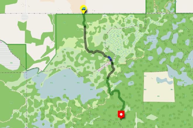
Interactive Route Map#
To see all route waypoints, zoom into the map by pinching open on mobile, scrolling on desktop.
View route colour key
Download Hike Route and Description#
Hike Route and Waypoints File#
The “.gpx” file contains both the hike route and important waypoints referred to in the hike description. See the suggestions for mobile apps and open the “.gpx” file in one of those apps on your mobile device.
Mobile (Offline) Hike Route Description in PDF Format#
Cell service can go from spotty to non-existent in the Ministik. The leg-by-leg route directions you see on this page are duplicated in a PDF document (".pdf") you can download here to read on your mobile device while offline.