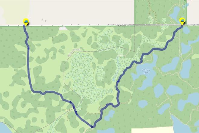
Francis Edward Williams Trailhead to the UofA Access Road Gate
Hike Details
| Trailheads: | Francis Edward Williams Trailhead |
| UofA Access Road Gate | |
| Hike Length: | 4.9 km |
| Route Type: | 2 Car |
| Difficulty: | Rated 84: Moderate 84 / 223 |
| ⓘ Ratings Explained |
Description#
This “2-Car” hike is a perfect “mid-level” option for those who have some Ministik experience under their belt. It takes you through a long string of connected hay meadows until you reach a section of the Waskahegan Trail and eventually the U of A Access Road.
The directions for this “2-Car” hike assume you’ll start at Francis Edward Williams Trailhead and walk to the U of A Field Station Access Road Gate. Of course you could do the hike in reverse; your choice.
View route colour key
Francis Edward Williams Trailhead ➜ Trail meets meadow
Distance: 370 m
Accumulated Distance: 370 m
Description
- You start off on a single-track trail that is usually easy to follow. As you get closer to the open meadow (now a hay field) trail can get more overgrown and more difficult to make out.
Trail meets meadow ➜ Meadow meets portal trail
Distance: 1.4 km
Accumulated Distance: 1.77 km
Description
- When you arrive at the open meadow use the trees in front of you in the middle of the meadow as beacons. You need to walk past them to start the meandering walk to the next waypoint.
- Use the track and the "Through the Labyrinth" waypoints to guide you through the twists and turns through the meadows.
Meadow meets portal trail ➜ Trail ends in open meadow
Distance: 92 m
Accumulated Distance: 1.862 km
Description
- This short section has become quite overgrown, but a path through it is usually easy to follow.
Trail ends in open meadow ➜ Portal trail (N)
Distance: 73 m
Accumulated Distance: 1.935 km
Description
- Now you walk through tall grass, what is left of a former water channel.
- Fun fact: as you cross this area, you leave Strathcona County and enter Beaver County. Do you feel any different? 😃
Portal trail (N) ➜ Portal trail (S)
Distance: 47 m
Accumulated Distance: 1.982 km
Description
- This cool little "portal" trail through the trees transports you to a large meadow to the south.
Portal trail (S) ➜ Trail meets large meadow (NE)
Distance: 314 m
Accumulated Distance: 2.296 km
Description
- While veering to the left a little, make your way toward the far side of the meadow.
- "Trail meets Shinjuku Meadow (NE)" is the waypoint you want to head towards.
- You'll see blue diamonds to mark the trail entrance.
Trail meets large meadow (NE) ➜ Trail / UofA Road Intersection
Distance: 1.1 km
Accumulated Distance: 3.396 km
Description
- Now we're on the Waskahegan Trail which is normally easily followed in any season.
- Make your way to "Trail - Farmer's Road Intersection" and then turn right to continue along the road.
- The road contours around a small meadow. Head for "Turn onto farmer's road" on the east side of the meadow.
- Turn to the north and follow the Waskahegan through "The Enchanted Forest" a collection of spruce, poplar and birch trees. The trees are somewhat sparse in this section. This often allows the sun to shine through beautifully through branches throwing rays of sunlight onto the forest floor.
- The trail meets the road at "Trail / UofA Road Intersection".
Trail / UofA Road Intersection ➜ UofA Access Road Gate
Distance: 1.5 km
Accumulated Distance: 4.896 km
Description
- Turn left onto the UofA Access Road and follow it to "UofA Access Road Gate".
- On the way you might want to take in the view at "Red Chair Lookout", a nice little knoll on the shore of Williams Lake.
- The road to the gate ends in a little hill for you to climb.
- Congratulations! You've experienced hay fields, forests and perhaps a little way finding along the way.
Interactive Route Map#
To see all route waypoints, zoom into the map by pinching open on mobile, scrolling on desktop.
View route colour key
Download Hike Route and Description#
Hike Route and Waypoints File#
The “.gpx” file contains both the hike route and important waypoints referred to in the hike description. See the suggestions for mobile apps and open the “.gpx” file in one of those apps on your mobile device.
Mobile (Offline) Hike Route Description in PDF Format#
Cell service can go from spotty to non-existent in the Ministik. The leg-by-leg route directions you see on this page are duplicated in a PDF document (".pdf") you can download here to read on your mobile device while offline.