Stick to the Field Station Road
Hike Details
| Trailhead: | UofA Access Road Gate |
| Hike Length: | 5.6 km |
| Route Type: | Out & Back |
| Difficulty: | Rated 55: Easy 55 / 223 |
| ⓘ Ratings Explained |
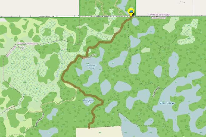
Description#
This hike is all about easy navigation: you follow a road for the entire hike—a rare thing in the Ministik. If this is your first time hiking in the area, this makes it a perfect introductory hike.
View route colour key
UofA Access Road Gate ➜ UofA Research Station Gate
Distance: 2.8 km
Description
- Park off the road at the "UofA Access Road Gate".
- Start down the hill and wind your way towards Williams Lake. Once you arrive there, you'll want to take in the nice view at "Red Chair Lookout", named after a red folding chair that was carted out to the viewpoint and remained there for years.
- This road is part of the Waskahegan Trail, a small section of which meanders through a large part of the Ministik. You might notice blue trail markers both before and after you reach Williams Lake. These mark off-road sections of the Waskahegan Trail. These sections are seldom travelled these days, so sticking to the road is your best bet, especially if you're new to area.
- The road turns sharply to the east and continues along the end of "Big Fish Meadow". From the ground the name makes no sense; but look at the area on the map and you'll soon understand.
- After turning sharply to the south the road ends at the gate of the Ministik Wildlife Research Station. Please heed the signs and go no further: it's private property beyond this fence.
- Now all there is to do is turn around and return on the road to the parking spot.
- Here's hoping you had a nice leisurely amble in the Ministik!
Interactive Route Map#
To see all route waypoints, zoom into the map by pinching open on mobile, scrolling on desktop.
View route colour key
Download Hike Route and Description#
Hike Route and Waypoints File#
The “.gpx” file contains both the hike route and important waypoints referred to in the hike description. See the suggestions for mobile apps and open the “.gpx” file in one of those apps on your mobile device.
Mobile (Offline) Hike Route Description in PDF Format#
Cell service can go from spotty to non-existent in the Ministik. The leg-by-leg route directions you see on this page are duplicated in a PDF document (".pdf") you can download here to read on your mobile device while offline.