The Enchanted Forest Loop
Hike Details
| Trailhead: | UofA Access Road Gate |
| Hike Length: | 4.2 km |
| Route Type: | Loop |
| Difficulty: | Rated 45: Easy 45 / 223 |
| ⓘ Ratings Explained |
Description#
The majority of this hike is along the U of A Field Station Access Road, but instead of remaining on the road the entire time, it takes you on a short section of the Waskahegan Trail, loops through a small forested area, and returns to the road. This is a nice introduction to the quiet, understated beauty of this area.
View route colour key
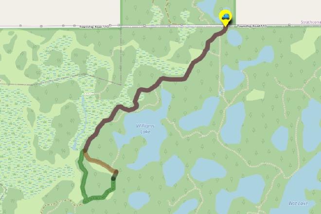
UofA Access Road Gate ➜ Road / Waskahegan Trail Intersection
Distance: 1.5 km
Accumulated Distance: 1.5 km
Description
- Park off the road at the "UofA Access Road Gate".
- Start down the hill and wind your way towards Williams Lake. Once you arrive there, you'll want to take in the nice view at "Red Chair Lookout", named after a red folding chair that was carted out to the viewpoint and remained there for years.
- This road is part of the Waskahegan Trail, a small section of which meanders through a large part of the Ministik. You might notice blue trail markers both before and after you reach Williams Lake. These mark off-road sections of the Waskahegan Trail. These sections are seldom travelled these days, so sticking to the road is your best bet, especially if you're new to the area. the map and you'll soon understand.
Road / Waskahegan Trail Intersection ➜ Trail meets farmer's road
Distance: 734 m
Accumulated Distance: 2.234 km
Description
- At the "Road / Waskahegan Trail Intersection" waypoint, bear right off the road onto the well-worn single-track trail.
- Now you wind your way through a somewhat sparse, yet nicely shaded forest of poplar, spruce and birch. The sparseness of the trees often allows the sun to filter through branches to the ground, providing the experience the Japanese call "komorebi". Although the term literally translates to "sunlight filtering through trees" it expresses that feeling of each moment being transient, part of the flow of things and the aesthetically beautiful.
- That's why it's "The Enchanted Forest".
- Follow the trail until reach an open area to your right. The trail gets harder to make out for a few meters here but look for the yellow Waskahegan Trail markers to guide you to a farmer's road.
- Turning right at this point will take you further into the Ministik, but the route today takes us back towards the parking spot.
- Turn left and follow the makeshift, overgrown road until you reach the edge of "Big Fish Meadow". From the ground, the name makes no sense; but look at the area on the map and you'll soon understand.
Trail meets farmer's road ➜ "Big Fish Meadow"
Distance: 54 m
Accumulated Distance: 2.288 km
Description
- Walk straight across the meadow to the U of A Access Road.
UofA Access Road ➜ UofA Access Road Gate
Distance: 1.8 km
Accumulated Distance: 4.088 km
Description
- Turn left when you reach the road and follow it all the way back to the Access Road Gate where you parked.
- Congratulations! You experienced a nice little hike and hopefully a taste of the serenity and beauty that this area can offer.
Interactive Route Map#
To see all route waypoints, zoom into the map by pinching open on mobile, scrolling on desktop.
View route colour key
Download Hike Route and Description#
Hike Route and Waypoints File#
The “.gpx” file contains both the hike route and important waypoints referred to in the hike description. See the suggestions for mobile apps and open the “.gpx” file in one of those apps on your mobile device.
Mobile (Offline) Hike Route Description in PDF Format#
Cell service can go from spotty to non-existent in the Ministik. The leg-by-leg route directions you see on this page are duplicated in a PDF document (".pdf") you can download here to read on your mobile device while offline.