Trek to the Ministik Fire Tower
Hike Details
| Trailhead: | UofA Access Road Gate |
| Hike Length: | 9.4 km |
| Route Type: | Out & Back |
| Difficulty: | Rated 131: Strenuous 131 / 223 |
| ⓘ Ratings Explained |
Description#
Starting out on the U of A Access Road, and after transitioning to the Waskahegan Trail, this hike takes you to one of the few historical landmarks in the area: the Ministik Firetower. This is a “must-do” hike for someone with some Ministik hiking experience under their belt.
View route colour key
UofA Access Road Gate ➜ UofA Access Road / Waskahegan Trail Intersection
Distance: 1.5 km
Accumulated Distance: 1.5 km
Description
- After parking at the "UofA Access Road Gate", start down the hill and wind your way towards Williams Lake.
- Once you arrive there, you'll want to take in the nice view at "Red Chair Lookout", named after a red folding chair that was carted out to the viewpoint and remained there for years.
- This road is part of the Waskahegan Trail, a small section of which meanders through a large part of the Ministik. You might notice blue trail markers both before and after you reach Williams Lake. These mark off-road sections of the Waskahegan Trail. These sections are seldom travelled these days, so sticking to the road is your best bet, especially if you're new to the area.
UofA Access Road / Waskahegan Trail Intersection ➜ Trail meets Shinjuku Meadow (NE)
Distance: 1.1 km
Accumulated Distance: 2.6 km
Description
- At the "U of A Access Road / Waskahegan Trail Intersection" waypoint, bear right off the road onto the well-worn single-track trail.
- Now you wind your way through a somewhat sparse, yet nicely shaded forest of poplar, spruce and birch. The sparseness of the trees often allows the sun to filter through branches to the ground, providing the experience the Japanese call "komorebi". Although the term literally translates to "sunlight filtering through trees" it expresses that feeling of each moment being transient, part of the flow of things and the aesthetically beautiful.
- That's why it's "The Enchanted Forest".
- Follow the trail to the "Turn onto farmer's road" waypoint.
- You'll reach an open area to your right. The trail gets a little harder to make out for a few meters here but look for the yellow Waskahegan Trail markers on nearby trees in front of you. They'll guide you to a farmer's road.
- Now turn right and follow the road around the edge of this little hay field. Your waypoint is "Intersection of Farmer's Road (N) / Waskahegan Trail".
- At "Intersection of Farmer's Road (N) / Waskahegan Trail" veer to the left to follow the spruce-lined trail and walk until you reach "Trail meets Shinjuku Meadow (NE)" (named after Shinjuku Station in Tokyo which has almost as many entrances and exits as this large, central Ministik hay field).
Trail meets Shinjuku Meadow (NE) ➜ Trail meets Shinjuku Meadow (SW)
Distance: 450 m
Accumulated Distance: 3.05 km
Description
- Now you need to make your way straight ahead to the far end of the field to the east. Use the waypoints "Shinjuku Meadow 1" and "Shinjuku Meadow 2" to guide you.
Trail meets Shinjuku Meadow (SW) ➜ Ministik Firetower
Distance: 1.5 km
Accumulated Distance: 4.55 km
Description
- When you reach "Waskahegan Trail meets Shinjuku Meadow (SW)" you'll see a wide section of the Waskahegan Trail. When you come to the foot of a small hill, follow the trail to the right, up the hill
- When you reach the bottom of the small hill at "Waskahegan Trail meets road to meadow", resist the urge to continue along the road to the right. Instead continue straight ahead along the single-track trail into the forest. The yellow trail markers will guide you.
- From this point until you reach the Ministik Firetower the trail will be clear. Remember, this entire area is made up of "knob and kettle" terrain: "knobs", small hills heaved up as glaciers melted and "kettles", depressed areas that retain water to form small lakes and ponds. This means there will be occasional small hills and valleys to traverse.
- When you reach the Ministik Firetower you'll see the old structure looks exceptionally rickety, so climbing it to any significant height is not recommended.
- But taking a much-deserved rest here is highly recommended! 😃
- When you decide to return, use the same waypoints to find your way back to the parking spot at "UofA Access Road Gate"
- Congratulations! You've traversed a lot of ground today and experienced one of the "must do" hikes in the Ministik!
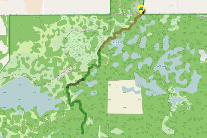
Interactive Route Map#
To see all route waypoints, zoom into the map by pinching open on mobile, scrolling on desktop.
View route colour key
Download Hike Route and Description#
Hike Route and Waypoints File#
The “.gpx” file contains both the hike route and important waypoints referred to in the hike description. See the suggestions for mobile apps and open the “.gpx” file in one of those apps on your mobile device.
Mobile (Offline) Hike Route Description in PDF Format#
Cell service can go from spotty to non-existent in the Ministik. The leg-by-leg route directions you see on this page are duplicated in a PDF document (".pdf") you can download here to read on your mobile device while offline.