Five Meadows Loop
Hike Details
| Trailhead: | UofA Access Road Gate |
| Hike Length: | 12.6 km |
| Route Type: | Loop |
| Difficulty: | Rated 169: Expedition 169 / 223 |
| ⓘ Ratings Explained |
Description#
Starting from the U of A Access Road Gate, this hike traverses sections of the established Waskahegan Trail as well as a series of five “off-trail” hay meadows on a wide loop that takes you into the inner depths of the Ministik, eventually passing the Ministik Firetower.
View route colour key
UofA Access Road Gate ➜ Road / Trail Intersection
Distance: 1.5 km
Accumulated Distance: 1.5 km
Description
- After parking at the "UofA Access Road Gate" start down the hill and wind your way towards Williams Lake.
- Once you arrive there, you'll want to take in the nice view at "Red Chair Lookout", named after a red folding chair that was carted out to the viewpoint and remained there for years.
Road / Trail Intersection ➜ Trail meets Shinjuku Meadow (NE)
Distance: 1.1 km
Accumulated Distance: 2.6 km
Description
- At the "U of A Access Road / Waskahegan Trail Intersection" waypoint, bear right off the road onto the well-worn single-track trail through "The Enchanted Forest".
- Make your way to the "Turn onto farmer's road" waypoint and turn right, following the road.
- At the "Intersection of Farmer's Road (N) / Waskahegan Trail" waypoint veer left to the shaded, spruce-lined trail.
- Continue until you reach "Trail meets Shinjuku Meadow (NE)"
Trail meets Shinjuku Meadow (NE) ➜ Trail meets Shinjuku Meadow (SW)
Distance: 450 m
Accumulated Distance: 3.05 km
Description
- Now you need to make your way straight ahead to the far end of the field to the east. Use the waypoints "Shinjuku Meadow 1" and "Shinjuku Meadow 2" to guide you.
Trail meets Shinjuku Meadow (SW) ➜ Road meets meadow 1 (N)
Distance: 436 m
Accumulated Distance: 3.486 km
Description
- Follow the wide trail to the right, up the hill
- When you reach the bottom of the small hill, bear right to follow the wide trail / road.
- We're leaving the Waskahegan trail at this point, but this hike plan has us looping around back to this place via the Waskahegan from the south.
- Use the "Road meets meadow 1 (N)" waypoint to get you started
Road meets meadow 1 (N) ➜ Meadow 1 (S) meets farmer's road
Distance: 300 m
Accumulated Distance: 3.786 km
Description
- Once into the meadow proper, keep the trees to your right as you round the corner.
- Make your way to a narrow gap at the end of the field to the "Meadow 1 (S) meets farmer's road" waypoint.
Meadow 1 (S) meets farmer's road ➜ Farmer's Road Meadow 2 (N)
Distance: 267 m
Accumulated Distance: 4.053 km
Description
- This is the first of a number of connector roads that allows the local farmers to transport haying implements from one field to the next.
Farmer's Road Meadow 2 (N) ➜ Meadow 2 (S) meets farmer's road
Distance: 171 m
Accumulated Distance: 4.224 km
Description
- Keep the trees on your left as you make your way to the far end of the meadow.
Meadow 2 (S) meets farmer's road ➜ Meadow 3 (S) meets farmer's road
Distance: 165 m
Accumulated Distance: 4.389 km
Description
- Another short connecting road makes the going easy here toward Meadow 3.
- This smaller Meadow 3 presents the opportunity for a detour to "Coyote Camp" for a rest break. There's often a game trail through the grass toward the north that leads to Coyote Camp.
- At this writing, the origin of Coyote Camp is unknown. There's a sign that announces the name of the place and a well-used fire pit.
Meadow 3 (S) meets farmer's road ➜ Meadow 4 (S) meets farmer's road
Distance: 223 m
Accumulated Distance: 4.612 km
Description
- Similar to Meadow 2, keep the trees to your left as you make your way southwest to the far end of the meadow. You're getting the hang of this by now right? 😃
Meadow 4 (S) meets farmer's road ➜ Farmer's road meets Meadow 5 (N)
Distance: 189 m
Accumulated Distance: 4.801 km
Description
- Follow the short connector trail to the next open area, Meadow 5.
Farmer's road meets Meadow 5 (N) ➜ Meadow 5 (S) meets portal trail
Distance: 275 m
Accumulated Distance: 5.076 km
Description
- When you reach the rather large Meadow 5, you won't see your next waypoint. Keep to the left and round the corner to a nice little portal trail at "Meadow 5 (S) meets portal trail"
Meadow 5 (S) meets portal trail ➜ Trail to Gnarly Game Trail (W)
Distance: 1.6 km
Accumulated Distance: 6.676 km
Description
- This section of hike is a favourite! It's always easy to follow and a joy to experience.
- Not far along the trail, you take a dip into and then again out of Leduc County.
Gnarly Game Trail (W) ➜ Gnarly Trail (E) meets open meadow
Distance: 297 m
Accumulated Distance: 6.973 km
Description
- This section of the trail gets you around the edge of the large pond. It's a narrow one-track trail with brambles growing thick on both sides.
Gnarly Game Trail (E) meets open meadow ➜ Trail meets old beaver dam
Distance: 239 m
Accumulated Distance: 7.212 km
Description
- The next goal is to make your way across the thick, usually tall grass of this former waterway.
- The Waskahegan Trail is on the far side of this open space, but nature seems to have reclaimed enough of it to make it hard to discern.
- Make your way the "Trail meets old beaver dam" waypoint, and you'll probably need to cross the beaver dam to get there.
Trail meets old beaver dam ➜ Trail meets Shinjuku Meadow (SW)
Distance: 2.3 km
Accumulated Distance: 9.512 km
Description
- Now we're on the Waskahegan Trail again. Phew!
- You'll pass the Ministik Firetower along the way. As you'll see the old structure looks exceptionally rickety, so climbing to any height is not recommended.
- Follow the trail north until you come to a point you've already encountered "Waskahegan Trail meets road to Meadow 1"
- Follow the trail up the hill and down again until you reach "Trail meets Shinjuku Meadow (SW)"
Trail meets Shinjuku Meadow (SW) ➜ Trail meets Shinjuku Meadow (NE)
Distance: 462 m
Accumulated Distance: 9.974 km
Description
- Use the waypoints "Shinjuku Meadow 2" and "Shinjuku Meadow 1" to make your way through the meadow and around the corner to "Portal trail (S)"
Trail meets Shinjuku Meadow (NE) ➜ Road / Trail Intersection
Distance: 1.1 km
Accumulated Distance: 11.074 km
Description
- Follow the Waskahegan trail back to now familiar "UofA Access Road / Waskahegan Trail Intersection".
UofA Access Road Gate ➜ Road / Waskahegan Trail Intersection ➜ UofA Access Road Gate ➜ Road
Distance: 1.5 km
Accumulated Distance: 12.574 km
Description
- It's the last leg! But thank goodness it's an easy go from here. Just follow the road back to the "UofA Access Road Gate".
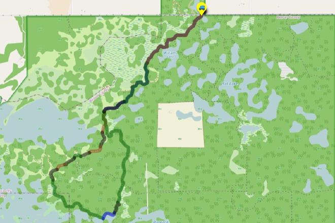
Interactive Route Map#
To see all route waypoints, zoom into the map by pinching open on mobile, scrolling on desktop.
View route colour key
Download Hike Route and Description#
Hike Route and Waypoints File#
The “.gpx” file contains both the hike route and important waypoints referred to in the hike description. See the suggestions for mobile apps and open the “.gpx” file in one of those apps on your mobile device.
Mobile (Offline) Hike Route Description in PDF Format#
Cell service can go from spotty to non-existent in the Ministik. The leg-by-leg route directions you see on this page are duplicated in a PDF document (".pdf") you can download here to read on your mobile device while offline.