Three Meadows Loop
Hike Details
| Trailhead: | UofA Access Road Gate |
| Hike Length: | 12.8 km |
| Route Type: | Loop |
| Difficulty: | Rated 168: Expedition 168 / 223 |
| ⓘ Ratings Explained |
Description#
Like the “Five Meadows Loop ”, this hike route takes you from the Waskahegan Trail through three “off-trail” hay meadows. But beware: the middle section of this hike may look like a sly shortcut compared to the “Five Meadows Loop,” but that shortcut is through perennially dodgy terrain where you’ll need to exercise your route-finding abilities.
Tip
Long sleeves and long pants are highly recommended for this hike.
View route colour key
UofA Access Road Gate ➜ Road / Trail Intersection
Distance: 1.5 km
Accumulated Distance: 1.5 km
Description
- After parking at the "UofA Access Road Gate" start down the hill and wind your way towards Williams Lake.
- Once you arrive there, you'll want to take in the nice view at "Red Chair Lookout", named after a red folding chair that was carted out to the viewpoint and remained there for years.
Road / Trail Intersection ➜ Trail meets Shinjuku Meadow (NE)
Distance: 1.1 km
Accumulated Distance: 2.6 km
Description
- At the "U of A Access Road / Waskahegan Trail Intersection" waypoint, bear right off the road onto the well-worn single-track trail through "The Enchanted Forest".
- Make your way to the "Turn onto farmer's road" waypoint and turn right, following the road.
- At the "Intersection of Farmer's Road (N) / Waskahegan Trail" waypoint veer left to the shaded, spruce-lined trail.
- Continue until you reach "Trail meets Shinjuku Meadow (NE)"
Trail meets Shinjuku Meadow (NE) ➜ Trail meets Shinjuku Meadow (SW)
Distance: 450 m
Accumulated Distance: 3.05 km
Description
- Now you need to make your way straight ahead to the far end of the field to the east. Use the waypoints "Shinjuku Meadow 1" and "Shinjuku Meadow 2" to guide you.
Trail meets Shinjuku Meadow (SW) ➜ Road meets meadow 1 (N)
Distance: 436 m
Accumulated Distance: 3.486 km
Description
- Follow the wide trail to the right, up the hill
- When you reach the bottom of the small hill, bear right to follow the wide trail / road.
- We're leaving the Waskahegan trail at this point, but this hike plan has us looping around back to this place via the Waskahegan from the south.
- Use the "Road meets meadow 1 (N)" waypoint to get you started
Road meets meadow 1 (N) ➜ Meadow 1 (S) meets farmer's road
Distance: 300 m
Accumulated Distance: 3.786 km
Description
- Once into the meadow proper, keep the trees to your right as you round the corner.
- Make your way to a narrow gap at the end of the field to the "Meadow 1 (S) meets farmer's road" waypoint.
Meadow 1 (S) meets farmer's road ➜ Farmer's Road Meadow 2 (N)
Distance: 267 m
Accumulated Distance: 4.053 km
Description
- This is the first of a number of connector roads that allows the local farmers to transport haying implements from one field to the next.
Farmer's Road Meadow 2 (N) ➜ Meadow 2 (S) meets farmer's road
Distance: 171 m
Accumulated Distance: 4.224 km
Description
- Keep the trees on your left as you make your way to the far end of the meadow.
Meadow 2 (S) meets farmer's road ➜ Game Trail Through the Bush
Distance: 165 m
Accumulated Distance: 4.389 km
Description
- Note: Since the trail on this leg is usually very obvious, there are a number of waypoints combined here.
- Another short connecting road makes the going easy here toward Meadow 3 at waypoint at "Farmer's road meets Meadow 3 (N)".
- Coyote Camp: This smaller Meadow 3 presents the opportunity for a detour to "Coyote Camp" for a rest break. There's often a game trail through the grass toward the north that leads to Coyote Camp.
- At this writing, the origin of Coyote Camp is unknown. There's a sign that announces the name of the place and a well-used fire pit.
- Continue to "Meadow 3 (S) meets farmer's road" and then the nearby "Farmer's road meets Meadow 4 (N)".
- Now you'll need to look to your left along the treeline to find the game trail that will take you "cross-country" toward the Fire Tower. Use the "Meadow meets game trail" waypoint to guide you.
Game Trail Through the Bush ➜ Trail meets gully
Distance: 307 m
Accumulated Distance: 4.696 km
Description
- The trail rating for the next three legs of the hike are blue and black for a reason: together they may test your route-finding abilities. Do your best to follow the provided track.
- Follow the game trail to the "Trail meets gully" waypoint.
Trail meets Gully ➜ Meadow meets gnarly game trail
Distance: 171 m
Accumulated Distance: 4.867 km
Description
- This leg will likely involve some basic "sight and go" orienteering. Use the "Meadow meets scant trail" waypoint to make sure you're heading in the right direction.
Meadow meets gnarly game trail ➜ Waskahegan Trail Intersection
Distance: 962 m
Accumulated Distance: 5.829 km
Description
- Much of this leg will involve moving along a game trail lined with thick scratchy bushes. But the trail is usually quite discernible.
- Use the "Trail / Waskahegan Trail intersection" waypoint to guide you in case the trail suddenly grows too faint.
Waskahegan Trail Intersection ➜ Trail meets Shinjuku Meadow (SW)
Distance: 1.8 km
Accumulated Distance: 7.629 km
Description
- Now we're back on the well-marked Waskahegan Trail. Keep on this trail, perhaps stopping for a well-deserved rest at the Ministik Firetower.
- Make your way back to the "Trail meets Shinjuku Meadow (SW)"
Trail meets Shinjuku Meadow (SW) ➜ Trail meets Shinjuku Meadow (NE)
Distance: 462 m
Accumulated Distance: 8.091 km
Description
- Use the waypoints "Shinjuku Meadow 2" and "Shinjuku Meadow 1" to make your way across the meadow to the "Trail meets Shinjuku Meadow (NE)" waypoint to continue on the Waskahegan Trail.
Trail meets Shinjuku Meadow (NE) ➜ Road / Trail Intersection
Distance: 1.1 km
Accumulated Distance: 9.191 km
Description
- Follow the Waskahegan trail back to now-familiar "UofA Access Road / Waskahegan Trail Intersection".
Road / Trail Intersection ➜ UofA Access Road Gate
Distance: 1.7 km
Accumulated Distance: 10.891 km
Description
- Now follow the road back to the "UofA Access Road Gate" waypoint.
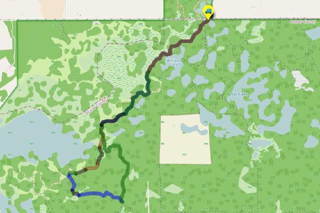
Interactive Route Map#
To see all route waypoints, zoom into the map by pinching open on mobile, scrolling on desktop.
View route colour key
Download Hike Route and Description#
Hike Route and Waypoints File#
The “.gpx” file contains both the hike route and important waypoints referred to in the hike description. See the suggestions for mobile apps and open the “.gpx” file in one of those apps on your mobile device.
Mobile (Offline) Hike Route Description in PDF Format#
Cell service can go from spotty to non-existent in the Ministik. The leg-by-leg route directions you see on this page are duplicated in a PDF document (".pdf") you can download here to read on your mobile device while offline.