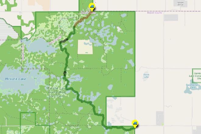
The Waskahegan Trail
Hike Details
| Trailheads: | UofA Access Road Gate |
| Fairbrother Corner Trailhead | |
| Hike Length: | 12.9 km |
| Route Type: | 2 Car |
| Difficulty: | Rated 192: Expedition 192 / 223 |
| ⓘ Ratings Explained |
Description#
This “2-Car” hike takes place exclusively on the Waskahegan Trail, the only trail in the Ministik that has trail markings and receives periodic maintenance. There are a couple of rough sections, and it’s relatively long at 13 km, earning it an “Expedition” rating on this site.
The directions for this “2-Car” hike assume you’ll start at U of A Field Station Access Road Gate and walk to the Fairbrother Corner Trailhead. Of course you could do the hike in reverse; your choice.
View route colour key
UofA Access Road Gate ➜ Road / Trail Intersection
Distance: 1.5 km
Accumulated Distance: 1.5 km
Description
- After parking at the "UofA Access Road Gate", start down the hill and wind your way towards Williams Lake.
- Once you arrive there, you'll want to take in the nice view at "Red Chair Lookout", named after a red folding chair that was carted out to the viewpoint and remained there for years.
Road / Trail Intersection ➜ Trail meets Shinjuku Meadow (NE)
Distance: 1.1 km
Accumulated Distance: 2.6 km
Description
- At the "U of A Access Road / Waskahegan Trail Intersection" waypoint, bear right off the road onto the well-worn single-track trail.
- Now you wind your way through a somewhat sparse, yet nicely shaded forest of poplar, spruce and birch. The sparseness of the trees often allows the sun to filter through branches to the ground, providing the experience the Japanese call "komorebi". Although the term literally translates to "sunlight filtering through trees" it expresses that feeling of each moment being transient, part of the flow of things and the aesthetically beautiful. That's why it's "The Enchanted Forest". 😃
- Follow the trail to the "Turn onto farmer's road" waypoint.
- You'll reach an open area to your right. The trail gets a little harder to make out for a few meters here, but look for the yellow Waskahegan Trail markers on nearby trees in front of you. They'll guide you to a farmer's road.
- Now turn right and follow the road around the edge of this little hay field. Your waypoint is "Intersection of Farmer's Road (N) / Waskahegan Trail".
- At "Intersection of Farmer's Road (N) / Waskahegan Trail" veer to the left to following the spruce-line trail and walk until you reach "Trail meets Shinjuku Meadow (NE)" (named after Shinjuku Station in Tokyo which has almost as many entrances and exits as this large, central Ministik hay field).
Trail meets Shinjuku Meadow (NE) ➜ Trail meets Shinjuku Meadow (SW)
Distance: 450 m
Accumulated Distance: 3.05 km
Description
- Now you need to make your way straight ahead to the far end of the field to east. Use the waypoints "Shinjuku Meadow 1" and "Shinjuku Meadow 2" to guide you.
Trail meets Shinjuku Meadow (SW) ➜ Trail meets old beaver dam
Distance: 2.3 km
Accumulated Distance: 5.35 km
Description
- When you reach "Waskahegan Trail meets Shinjuku Meadow (SW)" you'll see a wide section of the Waskahegan Trail. When you come to the foot of a small hill, follow the trail to the right, up the hill
- When you reach the bottom of the small hill at "Waskahegan Trail meets road to meadow", resist the urge to continue along the road to the right. Instead continue straight ahead along the single-track trail into the forest. The yellow trail markers will guide you.
- From this point until you reach the Ministik Firetower the trail is generally clear and easy to follow. Remember, this entire area is made up of "knob and kettle" terrain: "knobs", small hills heaved up as glaciers melted and "kettles" depressed areas that retain water to form small lakes and ponds. This means there will be occasional small hills and valleys to traverse.
- When you reach the Ministik Firetower you'll see the old structure looks exceptionally rickety, so climbing to any height is not recommended.
- But taking a much-deserved rest here is highly recommended! 😃
- Continue on south along the trail using the "Trail meets old beaver dam" waypoint to guide you.
Trail meets old beaver dam ➜ Waskahegan meets old meadow
Distance: 219 m
Accumulated Distance: 5.569 km
Description
- Make your way across the beaver dam. The trail is usually easy to identify near the dam, but nature is doing its thing and reclaiming this area. Make your way either along the edge of the thick, tall grass or through the hummocky grass itself.
- Use the "Waskahegan meets old meadow" waypoint to guide you back to a clear trail.
Waskahegan meets old meadow ➜ Fairbrother Corner Trailhead
Distance: 7.3 km
Accumulated Distance: 12.869 km
Description
- This long leg doesn't require too much description because it's all on the Waskahegan Trail, the only trail in the Ministik that receives periodic maintenance to remove deadfall and other obstacles.
- Keep an eye out for the yellow trail markers until you reach the Fairbrother Corner Trailhead.
- Congratulations! You've just completed one of the most challenging hikes on this site based on the trail difficulty rating. You should be proud of yourself!
Interactive Route Map#
To see all route waypoints, zoom into the map by pinching open on mobile, scrolling on desktop.
View route colour key
Download Hike Route and Description#
Hike Route and Waypoints File#
The “.gpx” file contains both the hike route and important waypoints referred to in the hike description. See the suggestions for mobile apps and open the “.gpx” file in one of those apps on your mobile device.
Mobile (Offline) Hike Route Description in PDF Format#
Cell service can go from spotty to non-existent in the Ministik. The leg-by-leg route directions you see on this page are duplicated in a PDF document (".pdf") you can download here to read on your mobile device while offline.