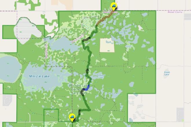
UofA Access Road Gate to Mandy Lake Parking
Hike Details
| Trailhead: | UofA Access Road Gate |
| Hike Length: | 10.3 km |
| Route Type: | 2-Car |
| Difficulty: | Rated 175: Expedition 175 / 223 |
| ⓘ Ratings Explained |
Description#
This “2-Car” epic hike starts out at the U of A Access Road gate, and traverses both the north and southern Ministik. The first half is on the Waskahegan Trail; the second takes you through some potentially tougher terrain until you reach the established Nesbit Trail. Be aware: this hike will require both stamina and wayfinding abilities and is intended for experienced hikers.
Tip
Long sleeves and long pants are highly recommended for this hike.
View route colour key
UofA Access Road Gate ➜ UofA Access Road / Waskahegan Trail Intersection
Distance: 1.5 km
Accumulated Distance: 1.5 km
Description
- After parking at the "UofA Access Road Gate", start down the hill and wind your way towards Williams Lake.
- Once you arrive there, you'll want to take in the nice view at "Red Chair Lookout", named after a red folding chair that was carted out to the viewpoint and remained there for years.
- This road is part of the Waskahegan Trail, a small section of which meanders through a large part of the Ministik. You might notice blue trail markers both before and after you reach Williams Lake. These mark off-road sections of the Waskahegan Trail. These sections are seldom travelled these days, so sticking to the road is your best bet, especially if you're new to the area.
UofA Access Road / Waskahegan Trail Intersection ➜ Trail meets Shinjuku Meadow (NE)
Distance: 1.1 km
Accumulated Distance: 2.6 km
Description
- At the "U of A Access Road / Waskahegan Trail Intersection" waypoint, bear right off the road onto the well-worn single-track trail.
- Now you wind your way through a somewhat sparse, yet nicely shaded forest of poplar, spruce and birch. The sparseness of the trees often allows the sun to filter through branches to the ground, providing the experience the Japanese call "komorebi". Although the term literally translates to "sunlight filtering through trees" or "dappled light", it expresses that feeling of the beauty of each moment being transient, part of the flow of things.
- That's why it's "The Enchanted Forest".
- Follow the trail to the "Turn onto farmer's road" waypoint.
- You'll reach an open area to your right. The trail gets a little harder to make out for a few meters here but look for the yellow Waskahegan Trail markers on nearby trees in front of you. They'll guide you to a farmer's road.
- Now turn right and follow the road around the edge of this little hay field. Your waypoint is "Intersection of Farmer's Road (N) / Waskahegan Trail".
- At "Intersection of Farmer's Road (N) / Waskahegan Trail" veer to the left to follow the spruce-line trail and walk until you reach "Trail meets Shinjuku Meadow (NE)" (named after Shinjuku Station in Tokyo which has almost as many entrances and exits as this large, central Ministik hay field).
Trail meets Shinjuku Meadow (NE) ➜ Trail meets Shinjuku Meadow (SW)
Distance: 450 m
Accumulated Distance: 3.05 km
Description
- Now you need to make your way straight ahead to the far end of the field to the east. Use the waypoints "Shinjuku Meadow 1" and "Shinjuku Meadow 2" to guide you.
Trail meets Shinjuku Meadow (SW) ➜ Trail meets old beaver dam
Distance: 2.9 km
Accumulated Distance: 5.95 km
Description
- This leg of the hike is entirely on the Waskahegan Trail so you can count on the trail being visible and marked with yellow diamonds the entire way.
- Bear right up the hill towards the "Waskahegan Trail meets road to meadow" waypoint.
- Follow the trail into the woods (not the road to the right).
- Continue past the "Ministik Firetower".
- The final waypoint of this leg is "Trail meets old beaver dam".
Trail meets old beaver dam ➜ Waskahegan meets old meadow
Distance: 291 m
Accumulated Distance: 6.241 km
Description
- This short section usually requires some wayfinding to navigate through.
- Cross the beaver dam and keep to the left, and skirt the open, grassy area using the "Waskahegan meets old meadow" as a waypoint to direct you.
Waskahegan meets old meadow ➜ Trail / Waskahegan Trail intersection
Distance: 1.1 km
Accumulated Distance: 7.341 km
Description
- Follow the trail as it winds through the woods. The trail can get overgrown in this area, so keep a watchful eye on your hike track log to ensure you're proceeding the right way.
- Make sure you have the "Trail / Waskahegan Trail intersection" dialed in because this turn off of the Waskahegan Trail onto a side trail is easy to miss.
Trail / Waskahegan Trail intersection ➜ Trail meets meadow
Distance: 431 m
Accumulated Distance: 7.772 km
Description
- We're off the Waskahegan Trail, so expect a degraded trail and no reassuring markers on the trail.
- This section is made up of various versions of what you might call a "good game trail" or "barely a hiking trail" - which means you'll need to follow the provided track to get you to your next waypoint "Trail meets meadow".
Trail meets meadow ➜ Meadow meets Nesbit Trail
Distance: 516 m
Accumulated Distance: 8.288 km
Description
- There is no trail in this section which eventually takes you over an old beaver dam and then through open, grassy (sometimes water-logged) meadows to the "Nesbit Trail". Use the provided waypoints to make your way through.
- Once over the old beaver dam, head towards "Meadow meets portal trail"
- Make your way to "Portal trail meets meadow" through an overgrown connector trail.
- Use "Meadow meets Nesbit Trail" as your next waypoint. You won't be able to see it when you start from "Portal trail meets meadow"; it's around the corner to the right from that waypoint.
Meadow meets Nesbit Trail ➜ Open Meadow Meets Trail (N)
Distance: 1.7 km
Accumulated Distance: 9.988 km
Description
- The Nesbit trail leading south from this point is used by sledders in the winter so you can count on it being quite clear.
- Make your way past the "Nesbit Trail meets E/W trail" intersection to the "N/S Trail - E/W Trails Intersection" waypoint where you'll turn left (south). In no time you come upon two small meadows connected by a game trail.
Open Meadow Meets Trail (N) ➜ Open Meadow Meets Trail (S)
Distance: 214 m
Accumulated Distance: 10.202 km
Description
- Make your way through the two small meadows to "Open Meadow Meets Trail (S)"
Open Meadow Meets Trail (S) ➜ Mandy Lake Road Trailhead
Distance: 815 m
Accumulated Distance: 11.017 km
Description
- Follow the well-worn trail past "Long Johns Junction" (so named because a pair of long johns hung in a tree near here for a couple of years - that must have been some party!).
- Turn right at the junction and continue to "Mandy Lake Road Trailhead".
- Congratulations on completing an epic hike in the Ministik!
Interactive Route Map#
To see all route waypoints, zoom into the map by pinching open on mobile, scrolling on desktop.
View route colour key
Download Hike Route and Description#
Hike Route and Waypoints File#
The “.gpx” file contains both the hike route and important waypoints referred to in the hike description. See the suggestions for mobile apps and open the “.gpx” file in one of those apps on your mobile device.
Mobile (Offline) Hike Route Description in PDF Format#
Cell service can go from spotty to non-existent in the Ministik. The leg-by-leg route directions you see on this page are duplicated in a PDF document (".pdf") you can download here to read on your mobile device while offline.