UofA Access Road Gate to Stove Lake via Ministik Fire Tower
Hike Details
| Trailheads: | UofA Access Road Gate |
| Stove Lake Trailhead | |
| Hike Length: | 9.6 km |
| Route Type: | 2 Car |
| Difficulty: | Rated 151: Strenuous 151 / 223 |
| ⓘ Ratings Explained |
Description#
At almost 10 km, this “2-Car” hike will test your stamina, but the trails themselves should be easy to follow throughout. After spending the first half on the Waskahegan Trail, you transition to a former cutline that is often traversed by sleds in the winter, making it fairly easy to follow.
The directions for this “2-Car” hike assume you’ll start at U of A Field Station Access Road Gate and walk to the Stove Lake Trailhead. Of course you could do the hike in reverse; your choice.
View route colour key
UofA Access Road Gate ➜ Road / Waskahegan Trail Intersection
Distance: 1.5 km
Accumulated Distance: 1.5 km
Description
- After parking at the "UofA Access Road Gate", start down the hill and wind your way towards Williams Lake.
- Once you arrive there, you'll want to take in the nice view at "Red Chair Lookout", named after a red folding chair that was carted out to the viewpoint and remained there for years.
- This road is part of the Waskahegan Trail, a small section of which meanders through a large part of the Ministik. You might notice blue trail markers both before and after you reach Williams Lake. These mark off-road sections of the Waskahegan Trail. These sections are seldom travelled these days, so sticking to the road is your best bet, especially if you're new to area.
Road / Waskahegan Trail Intersection ➜ Trail meets Shinjuku Meadow (NE)
Distance: 1.1 km
Accumulated Distance: 2.6 km
Description
- At the "U of A Access Road / Waskahegan Trail Intersection" waypoint, bear right off the road onto the well-worn single-track trail.
- Now you wind your way through a somewhat sparse, yet nicely shaded forest of poplar, spruce and birch. The sparseness of the trees often allows the sun to filter through branches to the ground, providing the experience the Japanese call "komorebi". Although the term literally translates to "sunlight filtering through trees" it expresses that feeling of each moment being transient, part of the flow of things and the aesthetically beautiful.
- That's why it's "The Enchanted Forest".
- Follow the trail to the "Turn onto farmer's road" waypoint.
- You'll reach an open area to your right. The trail gets a little harder to make out for a few meters here but look for the yellow Waskahegan Trail markers on nearby trees in front of you. They'll guide you to a farmer's road.
- Now turn right and follow the road around the edge of this little hay field. Your waypoint is "Intersection of Farmer's Road (N) / Waskahegan Trail".
- At "Intersection of Farmer's Road (N) / Waskahegan Trail" veer to the left to follow the spruce-line trail and walk until you reach "Trail meets Shinjuku Meadow (NE)" (named after Shinjuku Station in Tokyo which has almost as many entrances and exits as this large, central Ministik hay field).
Shinjuku Meadow (NE) ➜ Trail meets Shinjuku Meadow (SW)
Distance: 450 m
Accumulated Distance: 3.05 km
Description
- Now you need to make your way straight ahead to the far end of the field to the east. Use the waypoints "Shinjuku Meadow 1" and "Shinjuku Meadow 2" to guide you.
Trail meets Shinjuku Meadow (SW) ➜ Trail intersection
Distance: 1.8 km
Accumulated Distance: 4.85 km
Description
- This leg of the hike is entirely on the Waskahegan Trail so you can count on the trail being visible and marked with yellow diamonds the entire way.
- Bear right up the hill towards the "Waskahegan Trail meets road to meadow" waypoint.
- Follow the trail into the woods (not the road to the right).
- Continue past the "Ministik Firetower".
- The final waypoint of this leg is an important junction: "Waskahegan Trail / E-W Cutline intersection"
Trail intersection ➜ Ministik Crossroads intersection
Distance: 2.1 km
Accumulated Distance: 6.95 km
Description
- Turn left (east) and make your way down this cutline. There are no significant bends, turns or deviations from proceeding straight east.
- Use the "Ministik Crossroads intersection" waypoint to guide you.
Ministik Crossroads intersection ➜ Stove Lake Trailhead
Distance: 2.6 km
Accumulated Distance: 9.55 km
Description
- Turn right (south) and follow what is perennially a wide, clear trail to "Stove Lake Trailhead"
- When you reach the "Open Gate" make sure you transition to the left side of the fence. This trail leads to the parking spot and ensure you aren't traipsing over private property.
- Congratulations for finishing this substantial hike! You should be proud of your achievement.
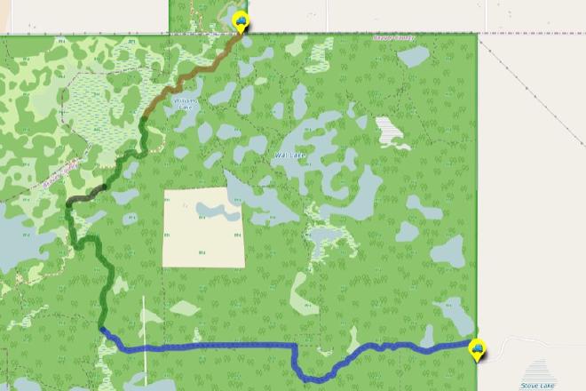
Interactive Route Map#
To see all route waypoints, zoom into the map by pinching open on mobile, scrolling on desktop.
View route colour key
Download Hike Route and Description#
Hike Route and Waypoints File#
The “.gpx” file contains both the hike route and important waypoints referred to in the hike description. See the suggestions for mobile apps and open the “.gpx” file in one of those apps on your mobile device.
Mobile (Offline) Hike Route Description in PDF Format#
Cell service can go from spotty to non-existent in the Ministik. The leg-by-leg route directions you see on this page are duplicated in a PDF document (".pdf") you can download here to read on your mobile device while offline.