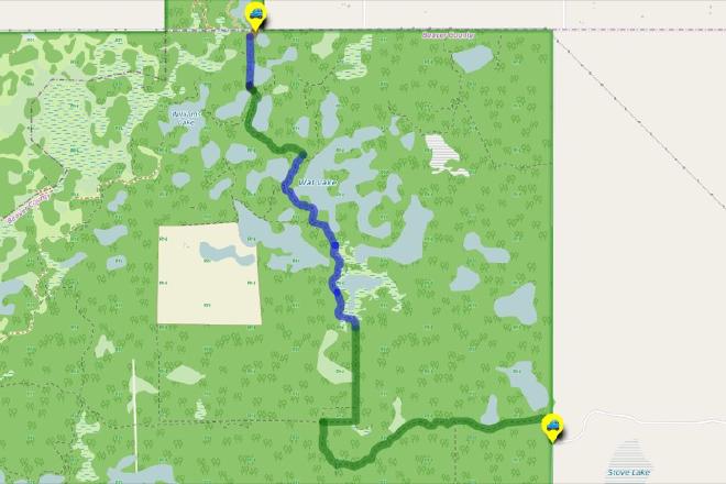
UofA Access Road Gate to Stove Lake via Deadfall Alley
Hike Details
| Trailheads: | UofA Access Road Gate |
| Stove Lake Trailhead | |
| Hike Length: | 7.3 km |
| Route Type: | 2 Car |
| Difficulty: | Rated 123: Strenuous 123 / 223 |
| ⓘ Ratings Explained |
Description#
This hike takes you on seldom-travelled trails, and because of that, many can be overgrown and hard to follow at times. This hike isn’t one of the longest on the site, but it ranks as one of the more strenuous because of the number of obstacles you will need to navigate.
The directions for this “2-Car” hike assume you’ll start at U of A Field Station Access Road Gate and walk to the Stove Lake Trailhead. Of course you could do the hike in reverse; your choice.
Tip
Long sleeves and long pants are highly recommended for this hike.
View route colour key
UofA Access Road Gate ➜ Hillside Trail
Distance: 67 m
Accumulated Distance: 67 m
Description
- Starting at the UofA Access Road Gate, walk around the first corner using the "Hillside Trail" waypoint.
- You may need to scan the trailside well to make out the trail because it's often very overgrown
Hillside Trail ➜ Detour Around Two-tiered Beaver Dam
Distance: 410 m
Accumulated Distance: 477 m
Description
- Descend the hill carefully. Use the "Detour Around Two-tiered Beaver Dam" to maintain your direction south.
- Always keep a careful watch for deadfall hidden in the grass underfoot.
Detour Around Two-tiered Beaver Dam ➜ Game Trail Through Trees
Distance: 53 m
Accumulated Distance: 530 m
Description
- In the past the two-tiered beaver dam to the left was the best way to cross the water obstacle. In a pinch that still might work.
- The better option these days is to follow the provided track that arcs around the wet spots and leads into a faint game trail at waypoint "Game Trail Through Bush".
Game Trail Through Trees ➜ Trail Intersection to Deadfall Alley
Distance: 0.89 km
Accumulated Distance: 1.42 km
Description
- This leg takes you to a pondside trail all the way to a turnoff down "Deadfall Alley".
- Make your way along the game trail to "Game Trail meets Pondside Trail".
- Turn right and follow the usually distinct pondside trail. This section can get very overgrown, especially in summer. The trail itself is there; but at times it's difficult to see. Keep an eye on the provided track to maintain your course.
- Use the "Trail Intersection to Deadfall Alley" as your next waypoint.
Trail Intersection to Deadfall Alley ➜ Old Gate
Distance: 0.77 km
Accumulated Distance: 2.19 km
Description
- You've made it to Deadfall Alley! There's even a sign here to mark the entrance.
- As the name of the section suggests, you'll find a lot of deadfall underfoot along this stretch.
- If you proceed with caution being mindful of what's on the ground in front of you, you'll be just fine.
- Use the "Old Gate" waypoint to guide you.
Old Gate ➜ Downhill Trail
Distance: 282 m
Accumulated Distance: 2.48 km
Description
- Here you'll notice what's left of an old gate that used to stand tall, but has since been wiped out by a fallen tree.
- This short section is part of a former cutline so it's usually quite easy to navigate.
- Use the "Downhill Trail" waypoint to guide you.
Downhill Trail ➜ Beaver Canals (W)
Distance: 0.66 km
Accumulated Distance: 3.14 km
Description
- This section of trail is mixed bag: the trail can be clear in spots and quite overgrown in spots, depending on the season.
- Use the track to guide you to the "Open area with beaver canals" waypoint.
Beaver Canals (W) ➜ Beaver Canals (E) ➜ Open Grassy Area (N)
Distance: 36 m
Accumulated Distance: 3.17 km
Description
- Make your way carefully over or around the beaver canals in this open area.
- The "Improved Trail Begins" waypoint marks the continuation of the trail which should be very easy to see.
Beaver Canals (E) ➜ Open Grassy Area (N)
Distance: 276 m
Accumulated Distance: 3.45 km
Description
- From here until the end of the hike the trail is usually much easier to follow.
- Make your way to "Open grassy area (N)".
Open Grassy Area (N) ➜ Open Grassy Area (S)
Distance: 73 m
Accumulated Distance: 3.52 km
Description
- Here you'll find a short section where there is no trail carved out on the earth, but it will be very easy to navigate in a straight line across to continue on a more established trail.
- That last sentence was longer than the open grassy area itself! 😃
Open Grassy Area (S) ➜ Ministik Crossroads
Distance: 1.1 km
Accumulated Distance: 4.62 km
Description
- The next major waypoint is the trail intersection at "Ministik Crossroads".
- On the way consider a rest stop at the "Lookout 'Throne'", a cool little spot overlooking what used to be a large pond.
- Turn right (east) at the "Old Gate (S)" waypoint; the way is obvious here.
Ministik Crossroads ➜ Stove Lake Trailhead
Distance: 2.6 km
Accumulated Distance: 7.22 km
Description
- At the "Ministik Crossroads" waypoint, take the trail south. The path is perennially clear here because locals keep it that way.
- Use the "Open Gate" waypoint as your next goal. Here you need to pass through the gate to get on the left side of the fence to ensure you don't continue onto private property.
- Use the "Stove Lake Trailhead" waypoint as your next and final waypoint.
- Congratulations! That was a trek and it might well have been a challenging one. Good for you for completing it!
Interactive Route Map#
To see all route waypoints, zoom into the map by pinching open on mobile, scrolling on desktop.
View route colour key
Download Hike Route and Description#
Hike Route and Waypoints File#
The “.gpx” file contains both the hike route and important waypoints referred to in the hike description. See the suggestions for mobile apps and open the “.gpx” file in one of those apps on your mobile device.
Mobile (Offline) Hike Route Description in PDF Format#
Cell service can go from spotty to non-existent in the Ministik. The leg-by-leg route directions you see on this page are duplicated in a PDF document (".pdf") you can download here to read on your mobile device while offline.