Stove Lake to Mandy Lake Parking
Hike Details
| Trailheads: | Stove Lake Trailhead |
| Mandy Lake Road Trailhead | |
| Hike Length: | 10 km |
| Route Type: | 2 Car |
| Difficulty: | Rated 164: Strenuous 164 / 223 |
| ⓘ Ratings Explained |
Description#
This hike takes you through the heart of the Ministik, on all kinds of trails: some usually clear, some usually dodgy. After traversing a cutline, you’ll take part of the Waskahegan Trail, then make your way to the Nesbit Trail on your way to the Mandy Lake Parking spot.
The directions for this “2-Car” hike assume you’ll start at Stove Lake Trailhead and walk to the Mandy Lake Road Trailhead. Of course you could do the hike in reverse; your choice.
Tip
Long sleeves and long pants are highly recommended for this hike.
View route colour key
Stove Lake Trailhead ➜ Trail meets old beaver dam
Distance: 5.1 km
Accumulated Distance: 5.1 km
Description
- Make your way past the gate and follow the short first leg due north.
- The trail turns sharply to the left (east) and continues to the "Open Gate" waypoint where you cross to the other side of the fence line you've been following.
- Make sure you bear right at "Trail Fork".
- At "Old Gate" walk through the fence opening onto the single-track trail.
- Following the trail to "Ministik Crossroads" should be quite straightforward.
- If a game trail intersects with the trail you're on, and you're ever in doubt, bear right. That will always be the correct choice.
- You might want to take a break when you reach "Ministik Crossroads".
- Turn left (east) at the intersection and make your way along this former cutline. The way should be quite clear along the way, but if in doubt use the "Three Trails intersection" waypoint to guide you.
- Turn left (south) at the "Three Trails intersection" and continue to "Trail meets old beaver dam" waypoint.
Trail meets old beaver dam ➜ Waskahegan meets old meadow
Distance: 239 m
Accumulated Distance: 5.339 km
Description
- This short section usually requires some wayfinding to navigate through.
- Cross the beaver dam and keeping to the left, skirt the open, grassy area using the "Waskahegan meets old meadow" as a waypoint to direct you.
Waskahegan meets old meadow ➜ Trail / Waskahegan Trail intersection
Distance: 1.1 km
Accumulated Distance: 6.439 km
Description
- Follow the trail as it winds through the woods. The trail can get overgrown in this area, so keep a watchful eye on your hike track log to ensure you're proceeding the right way.
- Make sure you have the "Trail / Waskahegan Trail intersection" dialed in because this turn off of the Waskahegan Trail onto a side trail is easy to miss.
Trail / Waskahegan Trail intersection ➜ Trail meets meadow
Distance: 431 m
Accumulated Distance: 6.87 km
Description
- We're off the Waskahegan Trail, so expect a degraded trail and no reassuring markers on the trail.
- This section is made up of various versions of what you might call a "good game trail" or "barely a hiking trail" - which means you'll need to follow the provided track to get you to your next waypoint "Trail meets meadow".
Trail meets meadow ➜ Nesbit Trail meets meadow
Distance: 516 m
Accumulated Distance: 7.386 km
Description
- There is no trail in this section that takes you over an old beaver dam and then over open meadows to the "Nesbit Trail". Use the provided waypoints to make your way through:
- Once over the old beaver dam, head towards "Portal trail (N)"
- Make your way through the overgrown connector passage to "Portal trail (S)".
- Use "Meadow meets Nesbit Trail" as your next waypoint. You won't be able to see it when you start from "Portal trail meets meadow"; it's around the corner to the right from that waypoint.
Nesbit Trail meets meadow ➜ Trail meets meadow (N)
Distance: 1.7 km
Accumulated Distance: 9.086 km
Description
- The Nesbit trail leading south from this point is used by sledders in the winter so you can count on it being quite clear.
- Make your way past the "Nesbit Trail meets E/W trail" intersection to the "N/S Trail - E/W Trails Intersection" waypoint where you'll turn left (south). In no time you come upon two small meadows connected by a game trail.
Trail meets meadow (N) ➜ Trail meets meadow (S)
Distance: 214 m
Accumulated Distance: 9.3 km
Description
- Make your way through the two small meadows to "Open Meadow Meets Trail (S)"
Trail meets meadow (S) ➜ Mandy Lake Road Trailhead
Distance: 815 m
Accumulated Distance: 10.115 km
Description
- Follow the well-worn trail past "Long Johns Junction" (so named because a pair of long johns hung in a tree near here for a couple of years - that must have been some party!).
- Turn right at the junction and continue to the "Mandy Lake Road Trailhead" waypoint.
- Congratulations on completing an epic hike in the Ministik!
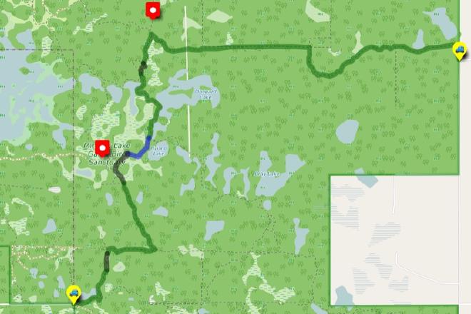
Interactive Route Map#
To see all route waypoints, zoom into the map by pinching open on mobile, scrolling on desktop.
View route colour key
Download Hike Route and Description#
Hike Route and Waypoints File#
The “.gpx” file contains both the hike route and important waypoints referred to in the hike description. See the suggestions for mobile apps and open the “.gpx” file in one of those apps on your mobile device.
Mobile (Offline) Hike Route Description in PDF Format#
Cell service can go from spotty to non-existent in the Ministik. The leg-by-leg route directions you see on this page are duplicated in a PDF document (".pdf") you can download here to read on your mobile device while offline.