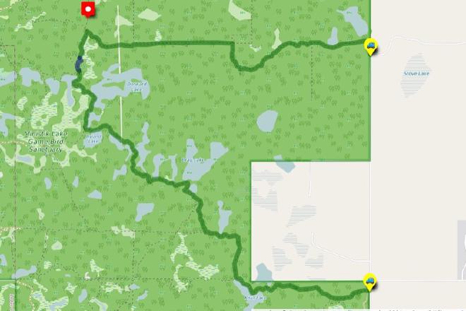
Stove Lake to Fairbrother Corner
Hike Details
| Trailheads: | Stove Lake Trailhead |
| Fairbrother Corner Trailhead | |
| Hike Length: | 12.6 km |
| Route Type: | 2 Car |
| Difficulty: | Rated 191: Expedition 191 / 223 |
| ⓘ Ratings Explained |
Description#
This hike rates as “Expedition” for a reason: it’s just about 13 km and covers a good portion of the Ministik. It’s a convenient “2-Car” option though: the departure and destination trailhead are along the same country road.
The directions for this “2-Car” hike assume you’ll start at Stove Lake Trailhead and walk to the Fairbrother Corner Trailhead. Of course you could do the hike in reverse; your choice.
View route colour key
Stove Lake Trailhead ➜ Trail meets old beaver dam
Distance: 5.1 km
Accumulated Distance: 5.1 km
Description
- Make your way past the gate and follow the short first leg due north.
- The trail turns sharply to the left (east) and continues to the "Open Gate" waypoint where you cross to the other side of the fence line you've been following.
- Make sure to bear right at "Trail Fork".
- At "Old Gate" walk through the fence opening onto the single-track trail.
- Following the trail to "Ministik Crossroads" should be quite straightforward.
- If a game trail intersects with the trail you're on, and you're ever in doubt, bear right. That will always be the correct choice.
- You might want to take a break when you reach "'Crossroads' intersection".
- Turn left (east) at the intersection and make your way along this former cutline. The way should be quite clear along the way, but if in doubt use the "Three Trails intersection" waypoint to guide you.
- Turn left (south) at the "Three Trails intersection" and continue to "Trail meets old beaver dam" waypoint.
Trail meets old beaver dam ➜ Waskahegan meets old meadow
Distance: 219 m
Accumulated Distance: 5.319 km
Description
- This short section usually requires some wayfinding to navigate through.
- Cross the beaver dam and, keeping to the left, skirt the open, grassy area using the "Waskahegan meets old meadow" as a waypoint to direct you.
Waskahegan meets old meadow ➜ Fairbrother Corner Trailhead
Distance: 7.3 km
Accumulated Distance: 12.619 km
Description
- We're now on the Waskahegan Trail, the only trail in Ministik that is officially maintained.
- The trail may be overgrown in sections, especially near Dorward Lake, but there are always markers along the trail to help you find your way.
- Make your way to the "Waskahegan Trail / North Cutline intersection" waypoint where you'll veer to the left.
- Continue to the "Waskahegan Trail / South Trail intersection" where a trail leading west is faint and you might not even notice it.
- The final section along Knull Lake may be overgrown, but the trail is usually still discernible.
- Use the "Fairbrother Corner Trailhead" waypoint to guide you.
- Congratulations! This hike took you through a good portion of the Ministik and you should be proud of yourself for completing it!
Interactive Route Map#
To see all route waypoints, zoom into the map by pinching open on mobile, scrolling on desktop.
View route colour key
Download Hike Route and Description#
Hike Route and Waypoints File#
The “.gpx” file contains both the hike route and important waypoints referred to in the hike description. See the suggestions for mobile apps and open the “.gpx” file in one of those apps on your mobile device.
Mobile (Offline) Hike Route Description in PDF Format#
Cell service can go from spotty to non-existent in the Ministik. The leg-by-leg route directions you see on this page are duplicated in a PDF document (".pdf") you can download here to read on your mobile device while offline.