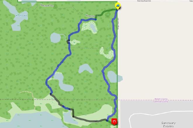
Marshall Mitchell Loop
Hike Details
| Trailhead: | Fairbrother Corner Trailhead Gate |
| Hike Length: | 6 km |
| Route Type: | Loop |
| Difficulty: | Rated 107: Moderate 107 / 223 |
| ⓘ Ratings Explained |
Description#
This hike is a combination of wide, easy trails punctuated with short crossings of trailless meadows in a seldom-travelled corner of the Ministik. Take a short detour to visit one of the few historical structures in the Ministik: the Marshall Mitchell Cabin. Marshall Mitchell lived in the cabin in the 1930’s while trapping and farming in the area.
View route colour key
Fairbrother Corner Trailhead ➜ Trail meets large meadow (N)
Distance: 1.7 km
Accumulated Distance: 1.7 km
Description
- Assuming a counter-clockwise loop, we start out along the wide, well-travelled Waskahegan Trail
- At the "Turn South from Waskahegan" waypoint, turn left (south)
- After a short walk south, turn right (west) "Turn east onto old road"
- The trail is wide and usually very clear of obstacles.
- Depending on the season at "Wet Spot" you'll encounter an area you might have to make your way around, or if it's dry, walk right over it.
- Use "Trail meets large meadow (N)" to guide you if you need it.
Trail meets large meadow (N) ➜ Trail meets large meadow (S)
Distance: 225 m
Accumulated Distance: 1.925 km
Description
- At "Trail meets large meadow (N)" you may have a map that offers a trail around this boggy spot, but experience shows that it's gnarly and challenging to follow.
- It's better to walk along the side of this former bog. Be very careful because beaver canals can be hidden under tall grass.
Trail meets large meadow (S) ➜ Trail meets open meadow (N)
Distance: 479 m
Accumulated Distance: 2.404 km
Description
- The clear, wide trail continues with the exception of a perennial "Wet Spot (S)".
- Skirt that spot and continue to "Trail meets open meadow (N)"
Trail meets open meadow (N) ➜ Trail meets open meadow (S)
Distance: 181 m
Accumulated Distance: 2.585 km
Description
- Make a sharp left turn and follow the edge of the large open meadow.
Trail meets open meadow (S) ➜ Trail continues (E)
Distance: 126 m
Accumulated Distance: 2.711 km
Description
- Here you'll find a makeshift trail made by quads.
- Continue to "Trail continues (E)"
Trail continues (E) ➜ Trail continues (W)
Distance: 103 m
Accumulated Distance: 2.814 km
Description
- The trail clears up in this short section.
- You come to another open meadow at "Trail continues (W)"
Trail continues (W) ➜ Quad through bush (N)
Distance: 71 m
Accumulated Distance: 2.885 km
Description
- Skirt around the edge of the grassy area using "Quad through bush (N)" as a waypoint.
- The entrance to the continuing trail can be a bit difficult to see, especially when the grass is tall, but a makeshift quad trail through the trees makes navigating around this rough area much easier.
Quad through bush (N) ➜ Quad through bush (S)
Distance: 105 m
Accumulated Distance: 2.99 km
Description
- Make your way along the makeshift quad trail to "Quad through bush (S)"
Quad through bush (N) ➜ Meadow meets side trail to cabin
Distance: 593 m
Accumulated Distance: 3.583 km
Description
- Make your way through the very large and picturesque meadow to "Meadow meets side trail to cabin". If you're lucky, a quad trail will guide you on your way.
Meadow meets side trail to cabin ➜ Marshall Mitchell Cabin & Return
Distance: 282 m
Accumulated Distance: 3.865 km
Description
- This section of the hike is optional. You could simply turn left (northeast) and follow this section of the Waskahegan Trail.
- But a trip to have a look at Marshall Mitchell Cabin is recommended. It's a small cabin still standing as of this writing. Another structure nearby hasn't fared as well.
- If you decided to visit, make your way back to "Meadow meets side trail to cabin" to continue the hike.
Meadow meets side trail to cabin ➜ Trail meets nasty spot (S)
Distance: 1 km
Accumulated Distance: 4.865 km
Description
- We'll be on the Waskahegan Trail for the rest of the hike, which means the trail will be marked and periodically maintained.
- Use "Trail meets nasty spot (S)" as your first waypoint.
Trail meets nasty spot (S) ➜ Trail meets nasty spot (N)
Distance: 30 m
Accumulated Distance: 4.895 km
Description
- As the waypoint name suggests, the original trail here has been compromised by beaver activity and random deadfall.
- Turn right (east) at "Trail meets nasty spot (S)" and make your way over the old beaver dam.
- Use "Trail meets nasty spot (N)" if you need to. It's just a few meters from the beaver dam.
Trail meets nasty spot (N) ➜ Trail meets open small meadow (S)
Distance: 290 m
Accumulated Distance: 5.185 km
Description
- Continue along the trail using "Trail meets open small meadow (S)" as your next waypoint.
Trail meets open small meadow (S) ➜ Trail meets open small meadow (N)
Distance: 74 m
Accumulated Distance: 5.259 km
Description
- Here you'll need to pick your way carefully across a former beaver pond. Be VERY careful here: deep beaver canals may not be obvious in tall grass. Falling into one unexpectedly could result in a broken leg.
- The way ahead isn't obvious here: head for the "Trail meets open small meadow (N)" to get across.
Trail meets open small meadow (N) ➜ Fairbrother Corner Trailhead
Distance: 758 m
Accumulated Distance: 6.017 km
Description
- Using "Fairbrother Corner Trailhead" as your next waypoint, make your way along this somewhat deteriorated section of the trail. There are good and bad spots, but generally it's not quite as clear as what you've seen so far along the Waskahegan Trail.
- Congratulations on finishing this grand loop hike!
Interactive Route Map#
To see all route waypoints, zoom into the map by pinching open on mobile, scrolling on desktop.
View route colour key
Download Hike Route and Description#
Hike Route and Waypoints File#
The “.gpx” file contains both the hike route and important waypoints referred to in the hike description. See the suggestions for mobile apps and open the “.gpx” file in one of those apps on your mobile device.
Mobile (Offline) Hike Route Description in PDF Format#
Cell service can go from spotty to non-existent in the Ministik. The leg-by-leg route directions you see on this page are duplicated in a PDF document (".pdf") you can download here to read on your mobile device while offline.