Mandy Lake Parking to Old Shelter
Hike Details
| Trailhead: | Mandy Lake Road Gate |
| Hike Length: | 4 km |
| Route Type: | Out & Back |
| Difficulty: | Rated 40: Easy 40 / 223 |
| ⓘ Ratings Explained |
Description#
This hike takes you along a former road, a rare thing in the Ministik. The going is easy, the navigation simple, which makes this a perfect choice for a starter hike. The final destination is a shelter that has seen better days, but still provides a roof and a place to rest for a while.
View route colour key
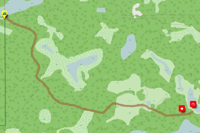
Mandy Lake Road Trailhead ➜ Round Shelter
Distance: 2 km
Description
- One aspect of this hike makes it rare among Ministik hikes: the entire hike is along a road. That makes it a great choice for a Ministik starter hike.
- Starting out from the parking spot at "Mandy Lake Road Trailhead" make sure you veer to the right once you pass through the gate.
- You'll wind your way along the old road and first pass an intersection at "Road / Oliver Lake Trail Intersection".
- Continue until you reach "Road meets Big Rock Meadow (W)" where the road degrades somewhat but is still quite easy to follow. The name of the meadow isn't commercial for a beer. It's because the path passes by a couple of big rocks, one of which just begs to be sat on. 😃
- The path becomes clearer at "Road meets Big Rock Meadow (E)"
- The trail gradually loses elevation just before you pass "Old Cabin", a structure that has definitely seen better days.
- Continue to the final "Round Shelter" waypoint. As you can see, this shelter has also seen better days. But it's a place where you can rest and perhaps even sign a makeshift "log book" to commemorate your visit.
- All that's left to do now is retrace your steps toward the parking spot to the west.
- Congratulations for completing the hike!
Interactive Route Map#
To see all route waypoints, zoom into the map by pinching open on mobile, scrolling on desktop.
View route colour key
Download Hike Route and Description#
Hike Route and Waypoints File#
The “.gpx” file contains both the hike route and important waypoints referred to in the hike description. See the suggestions for mobile apps and open the “.gpx” file in one of those apps on your mobile device.
Mobile (Offline) Hike Route Description in PDF Format#
Cell service can go from spotty to non-existent in the Ministik. The leg-by-leg route directions you see on this page are duplicated in a PDF document (".pdf") you can download here to read on your mobile device while offline.