UofA Access Road Gate via Five Meadows to Mandy Lake Parking
Hike Details
| Trailheads: | UofA Access Road Gate |
| Mandy Lake Road Trailhead | |
| Hike Length: | 11.1 km |
| Route Type: | 2 Car |
| Difficulty: | Rated 191: Expedition 191 / 223 |
| ⓘ Ratings Explained |
Description#
This “2-Car” hike is an epic expedition that will take you through the heart of the Ministik. You’ll experience easy sections on a road and clear trails, and a series of open meadows where there are no trails. Note the hike’s difficulty rating: it’s one of the most challenging on this site.
The directions for this “2-Car” hike assume you’ll start at U of A Field Station Access Road Gate and walk to the Mandy Lake Road Trailhead. Of course you could do the hike in reverse; your choice.
View route colour key
UofA Access Road Gate ➜ Road / Trail Intersection
Distance: 1.5 km
Accumulated Distance: 1.5 km
Description
- After parking at the "UofA Access Road Gate" start heading down the hill and wind your way towards Williams Lake.
- Once you arrive there, you'll want to take in the nice view at "Red Chair Lookout", named after the red folding chair that was carted out to the viewpoint and remained there for years.
Road / Trail Intersection ➜ Trail meets Shinjuku Meadow (NE)
Distance: 1.1 km
Accumulated Distance: 2.6 km
Description
- At the "U of A Access Road / Waskahegan Trail Intersection" waypoint, bear right off the road onto the well-worn single-track trail through "The Enchanted Forest".
- Make your way to the "Trail meets farmer's road" waypoint and turn right, following the road.
- At the "Intersection of Farmer's Road (N) / Waskahegan Trail" waypoint veer left to the shaded, spruce-lined trail.
- Continue until you reach "Trail meets Shinjuku Meadow (NE)"
Trail meets Shinjuku Meadow (NE) ➜ Trail meets Shinjuku Meadow (SW)
Distance: 450 m
Accumulated Distance: 3.05 km
Description
- Now you need to make your way straight ahead to the far end of the field to the east. Use the waypoints "Shinjuku Meadow 1" and "Shinjuku Meadow 2" to guide you.
Trail meets Shinjuku Meadow (SW) ➜ Road meets meadow 1 (N)
Distance: 436 m
Accumulated Distance: 3.486 km
Description
- Follow the wide trail to the right, up the hill
- When you reach the bottom of the small hill at "Waskahegan Trail meets road to meadow", bear right to follow the road (which actually looks like a wide trail).
- Use the "Road meets meadow 1 (N)" waypoint to guide you.
Road meets meadow 1 (N) ➜ Meadow 1 (S) meets farmer's road
Distance: 300 m
Accumulated Distance: 3.786 km
Description
- Once into the meadow proper, keep the trees to your right as you round the corner.
- Make your way to a narrow gap at the end of the field to the "Meadow 1 (S) meets farmer's road" waypoint.
Meadow 1 (S) meets farmer's road ➜ Farmer's Road Meadow 2 (N)
Distance: 267 m
Accumulated Distance: 4.053 km
Description
- This is the first of a number of connector roads that allows the local farmers to transport haying implements from one field to the next.
Farmer's Road Meadow 2 (N) ➜ Meadow 2 (S) meets farmer's road
Distance: 171 m
Accumulated Distance: 4.224 km
Description
- Keep the trees on your left as you make your way to the far end of the meadow.
Meadow 2 (S) meets farmer's road ➜ Meadow 3 (S) meets farmer's road
Distance: 165 m
Accumulated Distance: 4.389 km
Description
- Another short connecting road makes the going easy here toward Meadow 3.
- This smaller Meadow 3 presents the opportunity for a detour to "Coyote Camp" for a rest break. There's often a game trail through the grass toward the north that leads to Coyote Camp.
- At this writing, the origin of Coyote Camp is unknown. There's a sign announcing the name of the place and a well-used fire pit.
Meadow 3 (S) meets farmer's road ➜ Meadow 4 (S) meets farmer's road
Distance: 223 m
Accumulated Distance: 4.612 km
Description
- Similar to Meadow 2 keep the trees to your left as you make your way southwest to the far end of the meadow. You're getting the hang of this by now right? 😃
Meadow 4 (S) meets farmer's road ➜ Farmer's road meets Meadow 5 (N)
Distance: 189 m
Accumulated Distance: 4.801 km
Description
- Follow the short connector trail to the next open area, Meadow 5.
Farmer's road meets Meadow 5 (N) ➜ Meadow 5 (S) meets portal trail
Distance: 275 m
Accumulated Distance: 5.076 km
Description
- When you reach the rather large Meadow 5, you won't see your next waypoint. Keep to the left and round the corner to nice little portal trail at "Meadow 5 (S) meets portal trail"
Meadow 5 (S) meets portal trail ➜ Trail to Land Bridge Trail (N)
Distance: 1.3 km
Accumulated Distance: 6.376 km
Description
- The trail in this section is usually very easy to follow. There are no markers to guide you like you see along the Waskahegan Trail, but you shouldn't miss them here.
- Make your way to the "Land Bridge Trail (N)" waypoint.
Land Bridge Trail (N) ➜ Land Bridge (N)
Distance: 98 m
Accumulated Distance: 6.474 km
Description
- This is a pivotal point in the hike because here we turn south and keep going in that general direction until the end of the hike.
- Start on the short spur trail that takes you to "Land Bridge (N)"
Land Bridge (N) ➜ Land Bridge (S)
Distance: 198 m
Accumulated Distance: 6.672 km
Description
- This small "land bridge" connects the north portion of the Ministik to the south portion.
- The neighbourhood animals whose living room you are walking through undoubtedly use this bridge frequently.
- Make your way to "Land Bridge (S)".
Land Bridge (S) ➜ Meadow meets trail
Distance: 462 m
Accumulated Distance: 7.134 km
Description
- Now you need to make your way along the edge of the meadow to find an old trail on the far side. Use the "Meadow meets trail" waypoint to guide you across the large meadow.
Meadow meets trail ➜ Trail Intersection
Distance: 435 m
Accumulated Distance: 7.569 km
Description
- This must have been used in the past to skirt around the water both to the north and south of it, but that standing water is long gone. And the trail is going too, being slowly reclaimed by nature.
- Follow it to the "Trail Intersection" waypoint where you'll come to an open area.
Trail Intersection ➜ Meadow meets Nesbit Trail
Distance: 786 m
Accumulated Distance: 8.355 km
Description
- At this point you might want to have a rest at "The Diner" just around the corner. This spot is frequented by equestrians in summer and sledders in winter and you might find benches to sit on when you arrive.
- Continue on to the "Meadow meets portal trail" waypoint. You might see "shortcut" trails in the trees that promise a faster, shorter way to this goal. They might well be passable, but the sure thing is to follow the track the long way around the corner to the waypoint.
- If you need it, use the "Portal trail meets meadow" waypoint to make your way through a short "portal" trail.
- Now make your way across this open area to the "Meadow meets Nesbit Trail" waypoint.
Meadow meets Nesbit Trail ➜ Open Meadow Meets Trail (N)
Distance: 1.7 km
Accumulated Distance: 10.055 km
Description
- The trail south is used by sledders in winter so you can count on it being quite clear.
- Make your way past the "Nesbit Trail meets E/W trail" intersection to the "N/S Trail - E/W Trails Intersection" waypoint where you'll turn left (south). In no time you come upon two small meadows connected by a game trail.
Open Meadow Meets Trail (N) ➜ Open Meadow Meets Trail (S)
Distance: 214 m
Accumulated Distance: 10.269 km
Description
- Make your way through the two small meadows to "Open Meadow Meets Trail (S)"
Open Meadow Meets Trail (S) ➜ Mandy Lake Road Trailhead
Distance: 798 m
Accumulated Distance: 11.067 km
Description
- Follow the well-worn trail past "Long Johns Junction" (so named because a pair of long johns hung in a tree near here for a couple of years - that must have been some party!).
- Turn right at the junction and continue to "Mandy Lake Road Trailhead".
- Wow! That was an epic hike taking you through a major portion of the Ministik. Congratulations on your stamina, your tenacity, and your sense of adventure!
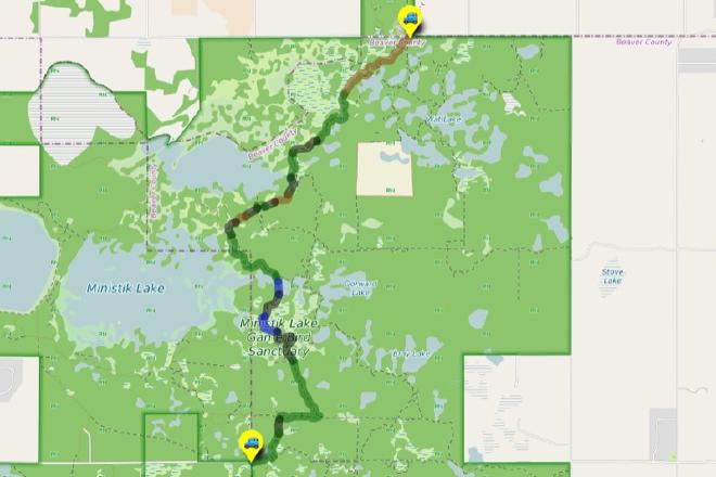
Interactive Route Map#
To see all route waypoints, zoom into the map by pinching open on mobile, scrolling on desktop.
View route colour key
Download Hike Route and Description#
Hike Route and Waypoints File#
The “.gpx” file contains both the hike route and important waypoints referred to in the hike description. See the suggestions for mobile apps and open the “.gpx” file in one of those apps on your mobile device.
Mobile (Offline) Hike Route Description in PDF Format#
Cell service can go from spotty to non-existent in the Ministik. The leg-by-leg route directions you see on this page are duplicated in a PDF document (".pdf") you can download here to read on your mobile device while offline.