North of Township Road 502 Loop
Hike Details
| Trailhead: | Mandy Lake Road Gate |
| Hike Length: | 5.1 km |
| Route Type: | Loop |
| Difficulty: | Rated 83: Moderate 83 / 223 |
| ⓘ Ratings Explained |
Description#
This somewhat awkwardly named hike takes you into a secluded set of trails not too far from parking. There are a couple of overgrown areas to traverse on the way, but otherwise trails are usually kept clear by local quad traffic.
View route colour key
Mandy Lake PK ➜ Open Meadow Meets Trail (S)
Distance: 815 m
Accumulated Distance: 815 m
Description
- Squeeze around the gate and veer left to start out along the pond-side trail using "Long Johns Junction" as your first waypoint.
- Turn left (north) at the junction and head towards "Open Meadow Meets Trail (S)" on the well-defined trail.
Open Meadow Meets Trail (S) ➜ Open Meadow Meets Trail (N)
Distance: 214 m
Accumulated Distance: 1.029 km
Description
- Here we traverse through two small, connected open meadows. Depending on the season, a game-worn trail usually shows the way, but use the "Open Meadow Meets Trail (N)" waypoint if needed.
Open Meadow Meets Trail (N) ➜ Wet - Overgrown Section
Distance: 411 m
Accumulated Distance: 1.440 km
Description
- Proceed to "N/S Trail - E/W Trail Junction".
- Turn left at the junction and continue to "Wet - Overgrown Section"
Wet - Overgrown Section ➜ Old Gate
Distance: 249 m
Accumulated Distance: 1.689 km
Description
- This section is always overgrown, but not always wet. Use the "Old Gate" waypoint if needed.
Old Gate & Loop Return ➜ Old Gate
Distance: 1.7 km
Accumulated Distance: 3.389 km
Description
- From this point on the trail can be overgrown in spots, but it's wide enough so that you always know how to proceed.
- This entire leg is a loop that will bring you back to this spot, so veering left or continuing due west is entirely up to you.
- Use either the "Northwest Trail Intersection" or the "Southwest Trail Intersection" waypoints to guide you, depending on your choice.
Old Gate ➜ Wet - Overgrown Section
Distance: 249 m
Accumulated Distance: 3.638 km
Description
- Return through the overgrown section. This time you should have good idea about how to proceed through.
Wet - Overgrown Section ➜ Open Meadow Meets Trail (N)
Distance: 411 m
Accumulated Distance: 4.049 km
Description
- Continue east along the trail, turn right (south) at "N/S Trail - E/W Trail Junction" and walk until you get to "Open Meadow Meets Trail (N)"
Open Meadow Meets Trail (N) ➜ Open Meadow Meets Trail (S)
Distance: 214 m
Accumulated Distance: 4.263 km
Description
- Make your way back through the two small open meadows to "Open Meadow Meets Trail (S)".
Open Meadow Meets Trail (S) ➜ Mandy Lake PK
Distance: 815 m
Accumulated Distance: 5.078 km
Description
- Follow the now familiar, well-worn trail to "Long Johns Junction".
- Turn right (west) and continue until you reach the "Mandy Lake Road Trailhead".
- Wasn't that a nice little jaunt into a secluded part of the earth you probably didn't know existed?
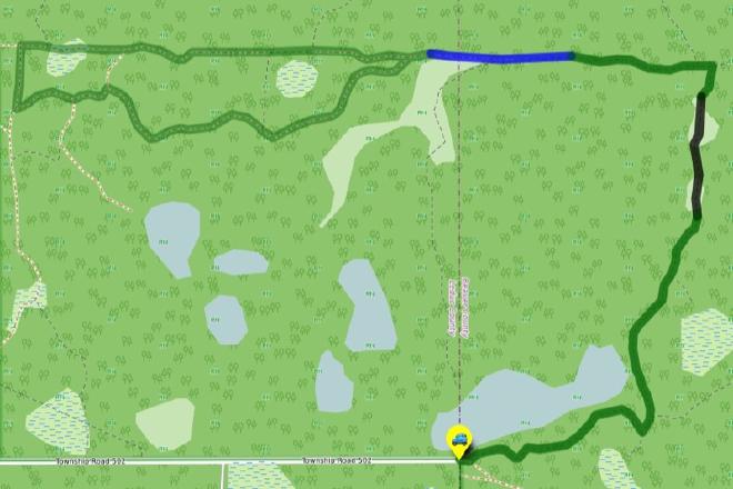
Interactive Route Map#
To see all route waypoints, zoom into the map by pinching open on mobile, scrolling on desktop.
View route colour key
Download Hike Route and Description#
Hike Route and Waypoints File#
The “.gpx” file contains both the hike route and important waypoints referred to in the hike description. See the suggestions for mobile apps and open the “.gpx” file in one of those apps on your mobile device.
Mobile (Offline) Hike Route Description in PDF Format#
Cell service can go from spotty to non-existent in the Ministik. The leg-by-leg route directions you see on this page are duplicated in a PDF document (".pdf") you can download here to read on your mobile device while offline.