Francis Edward Williams to Five Meadows Loop
Hike Details
| Trailhead: | Francis Edward Williams Trailhead |
| Hike Length: | 11.4 km |
| Route Type: | Loop |
| Difficulty: | Rated 223: Expedition 223 / 223 |
| ⓘ Ratings Explained |
Description#
Starting from the Francis Edward Williams trailhead, this hike traverses sections of the established Waskahegan Trail as well as a series of five “off-trail” hay meadows on a wide loop that takes you into the inner depths of the Ministik, eventually passing the Ministik Firetower.
View route colour key
Francis Edward Williams Trailhead ➜ Trail meets meadow
Distance: 370 m
Accumulated Distance: 370 m
Description
- You start off on a single-track trail that is usually easy to follow.
- As you get closer to the open meadow (now a hay field), the trail can get more overgrown and more difficult to make out.
Trail meets meadow ➜ Meadow meets portal trail
Distance: 1.4 km
Accumulated Distance: 1.77 km
Description
- When you arrive at the open meadow use the trees in front of you in the middle of the meadow as beacons. You need to walk past them to start the meandering walk to the next waypoint.
- Use the track and the "Through the Labyrinth" waypoints to guide you through the twists and turns through the meadows.
Meadow meets portal trail ➜ Trail ends in open meadow
Distance: 92 m
Accumulated Distance: 1.862 km
Description
- This short section has become quite overgrown, but a path through it is usually easy to follow.
Trail ends in open meadow ➜ Portal trail (N)
Distance: 73 m
Accumulated Distance: 1.935 km
Description
- Now you walk through tall grass, what is left of a former water channel. Sometimes this channel can be wet, so detour around that as best you can.
- Fun fact: as you cross this area, you leave Strathcona County and enter Beaver County. Do you feel any different? 😃
Portal trail (N) ➜ Portal trail (S)
Distance: 47 m
Accumulated Distance: 1.982 km
Description
- This cool little "portal" trail through the trees transports you to a large meadow to the south.
Portal trail (S) ➜ Trail meets Shinjuku Meadow (SW)
Distance: 462 m
Accumulated Distance: 2.444 km
Description
- As you exit the "portal" trail, keep veering to the right, making your way to "Shinjuku Meadow 1" waypoint.
- Like any Ministik meadow walk, there's no obvious trail to follow and the ground can be uneven. On the plus side there's no deadfall to dodge around and no prickly bushes to scratch your arms and legs.
- Proceed to the "Shinjuku Meadow 2" waypoint toward the southwest corner of the meadow.
- Once you round the corner, to the left you'll see a wide Waskahegan Trail which doubles as farmer's road.
Trail meets Shinjuku Meadow (SW) ➜ Road meets meadow 1 (N)
Distance: 436 m
Accumulated Distance: 2.88 km
Description
- Follow the wide trail to the right, up the hill
- When you reach the bottom of the small hill at "Waskahegan Trail meets road to meadow", bear right to follow the road (which actually looks like a wide trail).
- We're leaving the Waskahegan Trail at this point, but this hike plan has us looping around back to this place via the Waskahegan from the south.
- Use the "Road meets meadow 1 (N)" waypoint to get you started
Road meets meadow 1 (N) ➜ Meadow 1 (S) meets farmer's road
Distance: 300 m
Accumulated Distance: 3.18 km
Description
- Once into the meadow proper, keep the trees to your right as you round the corner.
- Make your way to a narrow gap at the end of the field to the "Meadow 1 (S) meets farmer's road" waypoint.
Meadow 1 (S) meets farmer's road ➜ Farmer's Road meets Meadow 2 (N)
Distance: 267 m
Accumulated Distance: 3.447 km
Description
- This is first of a number of connector roads that allows the local farmers to transport haying implements from one field to the next.
Farmer's Road meets Meadow 2 (N) ➜ Meadow 2 (S) meets farmer's road
Distance: 171 m
Accumulated Distance: 3.618 km
Description
- Keep the trees on your left as you make your way to the far end of the meadow.
Meadow 2 (S) meets farmer's road ➜ Meadow 3 (S) meets farmer's road
Distance: 165 m
Accumulated Distance: 3.783 km
Description
- Another short connecting road makes the going easy here toward Meadow 3.
- This smaller Meadow 3 presents the opportunity for a detour to "Coyote Camp" for a rest break. There's often a game trail through the grass to the north that leads to Coyote Camp.
- At this writing, the origin of Coyote Camp is unknown. There's a sign that announces the name of the place and a well-used fire pit.
Meadow 3 (S) meets farmer's road ➜ Meadow 4 (S) meets farmer's road
Distance: 223 m
Accumulated Distance: 4.006 km
Description
- Similar to Meadow 2 keep the trees to your left as you make your way southwest to the far end of the meadow. You're getting the hang of this by now right? 😃
Meadow 4 (S) meets farmer's road ➜ Farmer's road meets Meadow 5 (N)
Distance: 189 m
Accumulated Distance: 4.195 km
Description
- Follow the short connector trail to the next open area, Meadow 5.
Farmer's road meets Meadow 5 (N) ➜ Meadow 5 (S) meets portal trail
Distance: 275 m
Accumulated Distance: 4.47 km
Description
- When you reach the rather large Meadow 5, you won't see your next waypoint. Keep to the left and round the corner to nice little portal trail at "Meadow 5 (S) meets portal trail"
Meadow 5 (S) meets portal trail ➜ Gnarly Game Trail (W)
Distance: 1.6 km
Accumulated Distance: 6.07 km
Description
- This section of hike is a favorite! It's always easy to follow and a joy to experience.
- Not far along the trail, you take a dip into and then again out of Leduc County.
Gnarly Game Trail (W) ➜ Gnarly Trail (E)
Distance: 297 m
Accumulated Distance: 6.367 km
Description
- This section of the trail gets you around the edge of the large pond. It's a narrow one-track trail with brambles growing thick on both sides.
Gnarly Game Trail (E) ➜ Trail meets old beaver dam
Distance: 239 m
Accumulated Distance: 6.606 km
Description
- The next goal is to make your way across the thick, usually tall grass of this former waterway.
- The Waskahegan Trail is on the far side of this open space, but nature seemed to have reclaimed enough of it to make it hard to discern.
- Make your way to the "Trail meets old beaver dam" waypoint, and you'll probably need to cross the beaver dam to get there.
Trail meets old beaver dam ➜ Trail meets Shinjuku Meadow (SW)
Distance: 2.3 km
Accumulated Distance: 8.906 km
Description
- Now we're on the Waskahegan Trail again. Phew!
- You'll pass the Ministik Firetower along the way. As you'll see the old structure looks exceptionally rickety, so climbing to any height is not recommended.
- Follow the trail north until you come to point you've already encountered "Waskahegan Trail meets road to Meadow"
- Follow the trail up the hill and down again until you reach "Trail meets Shinjuku Meadow (SW)"
Trail meets Shinjuku Meadow (SW) ➜ Portal trail (S)
Distance: 462 m
Accumulated Distance: 9.368 km
Description
- Use the waypoints "Shinjuku Meadow 2" and "Shinjuku Meadow 1" to make your way through the meadow and around the corner to "Portal trail (S)"
Portal trail (S) ➜ Portal trail (N)
Distance: 47 m
Accumulated Distance: 9.415 km
Description
- Follow the short portal trail to "Portal trail (N)"
Portal trail (N) ➜ Trail ends in open meadow
Distance: 73 m
Accumulated Distance: 9.488 km
Description
- Cross the open area through the tall, thick grass to "Trail ends in open meadow"
Trail ends in open meadow ➜ Meadow meets portal trail
Distance: 92 m
Accumulated Distance: 9.58 km
Description
- Be careful to find the opening to this little connector trail. It can be very overgrown. Use the "Meadow meets portal trail" waypoint to guide you to the right place.
Meadow meets portal trail ➜ Trail meets meadow
Distance: 1.4 km
Accumulated Distance: 10.98 km
Description
- Use the track and the "Through the Labyrinth" waypoints to guide you through the twists and turns through the meadows.
- Once you turn the corner at "Through the Labyrinth 1" use the "beacon" tree in the middle of the meadow in front of you.
- Walk toward and then past them on the way to the "Trail meets meadow" waypoint
Trail meets meadow ➜ Francis Edward Williams Trailhead
Distance: 370 m
Accumulated Distance: 11.35 km
Description
- Follow the sometimes overgrown but usually easy to follow trail to the parking spot.
- Congratulations! Be proud of yourself for completing this substantial hike! 👍🏻🎉
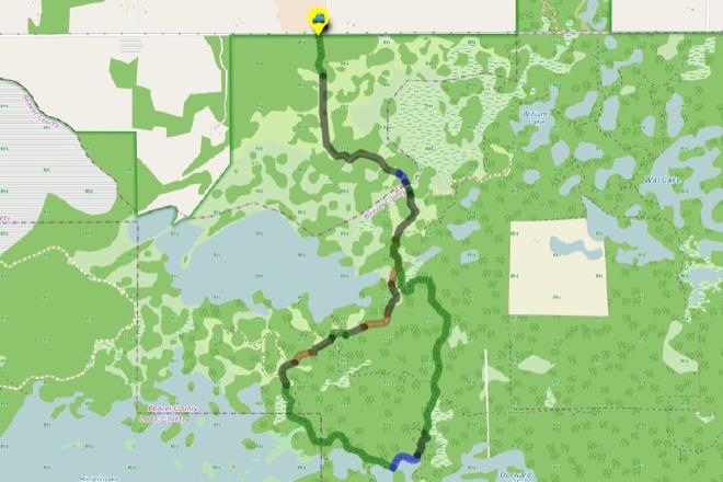
Interactive Route Map#
To see all route waypoints, zoom into the map by pinching open on mobile, scrolling on desktop.
View route colour key
Download Hike Route and Description#
Hike Route and Waypoints File#
The “.gpx” file contains both the hike route and important waypoints referred to in the hike description. See the suggestions for mobile apps and open the “.gpx” file in one of those apps on your mobile device.
Mobile (Offline) Hike Route Description in PDF Format#
Cell service can go from spotty to non-existent in the Ministik. The leg-by-leg route directions you see on this page are duplicated in a PDF document (".pdf") you can download here to read on your mobile device while offline.