Waskahegan Berg Section - Out & Back
Hike Details
| Trailhead: | Waskahegan Berg Section South Trailhead |
| Hike Length: | 7.4 km |
| Route Type: | Out & Back |
| Difficulty: | Rated 111: Moderate 111 / 223 |
| ⓘ Ratings Explained |
Description#
This hike is a perfect starter hike on a somewhat secluded trail that is usually in good shape. The route is rated as “Moderate” because it’s a little longer than other starter hikes. This is a part of the Waskahegan Trail and, as such, is periodically maintained and marked. It features the opportunity to visit “Berg Stopover”, a quaint little hut that welcomes passing hikers.
The hike is “out and back” so the idea is walk the length of trail and then double back to the parking spot where you started.
Tip
There are sections of this hike where scratchy bushes beside the trail grow over the trail. Long sleeves and long pants are highly recommended for this hike.
View route colour key
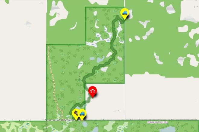
Berg Section South Trailhead (S) ➜ Berg Section North Trailhead (N)
Distance: 3.7 km
Accumulated Distance: 3.7 km
Description
- Park at "UofA Access Road Gate" and walk across the road to "Berg Section South Trailhead (S)". Parking at the trailhead itself is dangerous and could get you a ticket.
- The trail first winds around a beaver pond. It can be overgrown but is always quite easy to follow.
- You might want to stop in briefly at "Berg Stopover", a quaint little open-air structure that welcomes visitors. You are on private land here and are being welcomed as a guest, so please be respectful and, if possible, leave the place better than you found it.
- The trail winds through the "knob and kettle" terrain typical of this part of the province: "knobs", small hills heaved up as glaciers melted and "kettles" depressed areas that retain water to form small lakes and ponds.
- At the north end of the trail you'll need to climb a small hill to reach "Berg Section North Trailhead (N)" where you will turn around, retrace your steps while returning to the "Berg Section South Trailhead (S)"
Interactive Route Map#
To see all route waypoints, zoom into the map by pinching open on mobile, scrolling on desktop.
View route colour key
Download Hike Route and Description#
Hike Route and Waypoints File#
The “.gpx” file contains both the hike route and important waypoints referred to in the hike description. See the suggestions for mobile apps and open the “.gpx” file in one of those apps on your mobile device.
Mobile (Offline) Hike Route Description in PDF Format#
Cell service can go from spotty to non-existent in the Ministik. The leg-by-leg route directions you see on this page are duplicated in a PDF document (".pdf") you can download here to read on your mobile device while offline.