This Site's Trail Rating System
Table of Contents
Why a Trail Rating System?#
With the exception of the Waskahegan Trail, the trails in the Ministik provide none of these things. For that reason, someone new to the area should at least have some idea of what they’re getting themselves into when deciding on an outing in the area.
That’s where the trail rating system on this site comes in. It is meant to give you an indication of the combined navigational and physical effort you can expect when walking the trail.
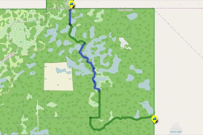
Each leg as been rated by the expected level of difficulty based on past experience hiking the trail and assigned a color to represent the usual trail conditions for that leg. Each level of difficulty has in turn been assigned a weighting from 1 to 2.5 to show the increased navigational and / or physical effort required to undertake the hike compared to other hikes on the site.
Trail Rating Categories and Associated Difficulty Weighted Values#
The levels of difficulty and weightings are:
- Brown - A road, so the going is easy and the route is always clear. (Weighted 1)
- Green - Usually a well-defined trail, occasionally overgrown. (Weighted 1.5)
- Blue - Trail often degraded or overgrown, therefore not well-defined. (Weighted 2)
- Black - No trail, so navigation is more difficult, yet sometimes there’s a game trail to follow. (Weighted 2.5)
How Route Difficulty Ratings Are Calculated#
The length of the route legs in meters is multiplied by the assigned difficulty weighting to come up with a total difficulty for that leg. The difficulty scores for each leg are totalled giving a difficulty rating for the entire hike. That total is then divided by 100 to yield a more manageable number.
For example,
- Walking 500 m on a road (Brown, weighted 1) would yield a difficulty score for the leg of (1 x 500) = 500.
- Walking 500 m where there is no trail (Black, weighted 2.5) would yield a difficulty score of (2.5 x 500) = 1250
The lengths of a legs are the same, but different trail conditions yield different scores giving a hiker some sense of the effort that might be required to walk the leg.
How Difficulty Rating Descriptors are Determined#
In an effort to help with the comparison of the many route options on the site, descriptors: “Easy”, “Moderate”, “Strenous”, and “Expedition” are assigned to routes based on their total ratings.
A hiking route’s difficulty rating score is divided by the highest hike difficulty rating on the site, currently 223. The result is assigned a descriptor based on this table:
	- < .25 = Easy
	- >= .25 and <=.5 = Moderate
	- >= .5 and <= .75 = Strenuous
	- >.75 = Expedition
It’s easy to see these descriptors are subjective: one person’s “Strenuous” may be another person’s “Moderate”. But the descriptors are provided to give hikers at least some idea of what level of effort the hike will likely entail.
A Disclaimer About Trail Ratings#
As just mentioned about the descriptors, the rating system as a whole is HIGHLY subjective. How highly subjective? Well, put your hand over your head and get on your tippy toes: that highly subjective. 😃
Have you noticed that when nature is left alone it has a way of changing the landscape any way it sees fit? Likewise, nature is constantly changing the trail conditions in the Ministik, both throughout the seasons in one year and over multiple years. That makes the ratings on this site only “best guesses” based on the experience of having walked the trails in the past. And of course the ratings only have meaning when compared to the ratings of other hikes on the site.
All that said, if you are unfamiliar with the area, the trail difficulty rating of does serve as an indicator (however fuzzy it might be) based on experiences of hiking the actual trails.